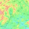
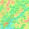
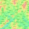
河源市 topographic maps
Click on a map to view its topography, its elevation and its terrain.
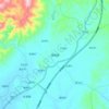
中国 > 广东省 > 河源市
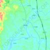
顺天镇, 河源市, 广东省, 中国
Average elevation: 139 m
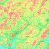
中国 > 广东省 > 河源市
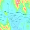
忠信镇, 河源市, 广东省, 中国
Average elevation: 196 m
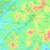
中国 > 广东省 > 河源市
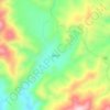
增坝村, 河源市, 广东省, 中国
Average elevation: 598 m
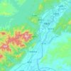
中国 > 广东省 > 河源市
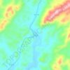
下青溪, 河源市, 广东省, 中国
Average elevation: 172 m
中国 > 广东省 > 河源市
绣缎镇, 河源市, 广东省, 中国
Average elevation: 207 m
中国 > 广东省 > 河源市
河源市, 广东省, 中国
Average elevation: 313 m
中国 > 广东省 > 河源市
紫金县, 河源市, 广东省, 中国
Average elevation: 259 m
中国 > 广东省 > 河源市
源城区, 河源市, 广东省, 中国
Average elevation: 173 m
中国 > 广东省 > 河源市
和平县, 河源市, 广东省, 中国
Average elevation: 309 m
中国 > 广东省 > 河源市
东源县, 河源市, 广东省, 中国
Average elevation: 275 m
中国 > 广东省 > 河源市
龙川县, 河源市, 广东省, 中国
Average elevation: 286 m
