
Europe topographic map
Interactive map
Click on the map to display elevation.
Europe
Europe's topography is characterized by a striking contrast between its rugged southern mountains and the expansive plains of the north. The continent is often described as a "peninsula of peninsulas," featuring major peninsulas like the Iberian, Italian, and Balkan, each with unique geological features. In the southern regions, mountain ranges such as the Alps and the Pyrenees rise dramatically, with elevations frequently exceeding 9,800 feet (3,000 meters). Moving northward, the terrain gradually descends into the Great European Plain, a vast lowland stretching from the Pyrenees in the west to the Ural Mountains in the east, where most elevations are below 1,640 feet (500 meters). This plain is interspersed with rolling hills and valleys, making it one of the most agriculturally productive areas in Europe, while also being historically significant due to its accessibility for trade and invasion. The northern regions, including Scandinavia and the British Isles, are marked by fjords and rugged uplands, contributing to a diverse and complex landscape across the continent.
About this map
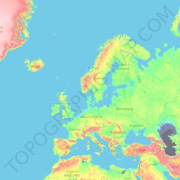
Name: Europe topographic map, elevation, terrain.
Location: Europe (26.00000 -15.00000 76.00000 35.00000)
Average elevation: 223 m
Minimum elevation: -30 m
Maximum elevation: 3,987 m
Other topographic maps
Click on a map to view its topography, its elevation and its terrain.
Serbia
Ancient mountains in the southeast corner of the country belong to the Rilo-Rhodope Mountain system. Elevation ranges from the Midžor peak of the Balkan Mountains at 2,169 metres (7,116 feet) (the highest peak in Serbia, excluding Kosovo) to the lowest point of just 17 metres (56 feet) near the Danube river…
Average elevation: 492 m
Nepal
Nepal is divided into three principal physiographic belts known as Himal–Pahad–Terai. Himal is the mountain region containing snow and situated in the Great Himalayan Range; it makes up the northern part of Nepal. It contains the highest elevations in the world including 8,848.86 metres (29,032 ft) height…
Average elevation: 2,604 m
Zurich
Switzerland > Zurich > District Zurich
On its west side, the Limmat valley is flanked by the wooded heights of the Albis chain, which runs along the western border. The Uetliberg is, with 869 m (2,851 ft) above sea level, the highest elevation of the surrounding area. Its summit can be reached easily by the Uetlibergbahn. From the platform of the…
Average elevation: 499 m
Roberto Clemente State Park
United States > New York > Bronx County > New York
Average elevation: 32 m
Wrocław
Poland > Lower Silesian Voivodeship
Wrocław is located in the three mesoregions of the Silesian Lowlands (Wrocław Plain, Wrocław Valley, Oleśnica Plain) at an elevation of around 105–156 metres (Gajowe Hill and Maślickie Hill) above sea level. The city lies on the Oder River and its four tributaries, which supply it within the city limits…
Average elevation: 125 m
Ontario
Despite the rarity of mountainous terrain in the province, there are large areas of uplands, particularly within the Canadian Shield, which traverses the province from northwest to southeast and also above the Niagara Escarpment, which crosses the south. The highest point is Ishpatina Ridge at 693 metres…
Average elevation: 245 m
Contra Costa County
In prehistoric times, particularly the Miocene epoch, portions of the landforms now in the area (then marshy and grassy savanna) were populated by a wide range of now extinct mammals, known in modern times by the fossil remains excavated in the southern part of the county. In the northern part of the county,…
Average elevation: 108 m
Karlsruhe
The city lies at an altitude of between 100 and 322 m (328 and 1,056 ft), the higher figure being near the communications tower in the suburb of Grünwettersbach. Its geographical coordinates are 49°00′N 8°24′E / 49.000°N 8.400°E / 49.000; 8.400; the 49th parallel runs through the city centre,…
Average elevation: 132 m
Rwanda
Rwanda, officially the Republic of Rwanda, is a landlocked country in East Africa. Known as the "Land of a Thousand Hills" for its high elevation and rolling terrain, its geography is dominated by mountains in the west and savanna in the southeast. The largest and most notable lakes are mainly in the western…
Average elevation: 1,625 m
Temagami
Canada > Ontario > Nipissing District
Temagami provides rugged topography, which is excellent for canoeing and hiking. There are numerous viewpoints in the municipality, including High Rock and Caribou Mountain, which contains a 100 ft (30 m) fire tower on its summit.
Average elevation: 319 m
Lesotho
Lesotho covers 30,355 km2 (11,720 sq mi). It is the only independent state in the world that lies entirely above 1,000 metres (3,281 ft) in elevation. Its lowest point of 1,400 metres (4,593 ft) is thus the highest lowest point of any country in the world. Over 80% of the country lies above 1,800 metres (5,906…
Average elevation: 1,958 m
Lumbini Province
The elevations of Dang and Deukhuri valleys are 700 meters and 300 meters from sea level respectively. Late Cenozoic sedimentary sequences are well exposed along the southern part of Dang and all sides of Deukhuri valley, and mostly consist of deformed rocks resulting from the persistence of shortening between…
Average elevation: 1,439 m
Peru
Although Peru is located entirely in the tropics, the combination of tropical latitude, mountain ranges, topography variations, and two ocean currents (Humboldt and El Niño) gives Peru a large diversity of climates. Elevations above sea level in the country range from −37 to 6,778 m (−121 to 22,238 ft)…
Average elevation: 645 m
Chapada Gaúcha
Chapada Gaúcha is a municipality in the northern region of Minas Gerais, Brazil. The population in 2020 was 13,953 in an area of 3,215 km2. The elevation of the municipal seat is 872 meters. It became a municipality in 1997. The postal code (CEP) is 39314-000.
Average elevation: 704 m
Lantsch/Lenz
Switzerland > Grisons > Albula
Until 2017, the municipality was located in the Belfort sub-district of the Albula district, after 2017 it was part of the Albula Region. It is located at an elevation of 1,294 m (4,245 ft) on a terrace above the right side of the Albula river. It consists of the linear village of Lantsch/Lenz. Until 1943…
Average elevation: 1,753 m
Comox Glacier
Canada > British Columbia > Alberni-Clayoquot Regional District > Area D (Sproat Lake)
Average elevation: 1,584 m
Navarre
Despite its relatively small size, Navarre features stark contrasts in geography, from the Pyrenees mountain range that dominates the territory to the plains of the Ebro river valley in the south. The highest point in Navarre is Mesa de los Tres Reyes, with an elevation of 2,428 metres (7,966 feet).
Average elevation: 629 m
Авала
Serbia > City of Belgrade > Vozdovac Urban Municipality > Beli Potok
It is still debated whether Šuplja Stena is a natural cave or was completely dug for the mining purposes. Remains of the Neanderthal culture were discovered in it. In his 1943 Prehistoric mine Šuplja Stena on Avala hill near Belgrade (Serbia), Vladimir Milojčić said that the "cave is old as Avala", formed…
Average elevation: 300 m
Космај
Serbia > City of Belgrade > Mladenovac Urban Municipality
Kosmaj (Serbian Cyrillic: Космај, pronounced [kɔ̌smaːj]) is a mountain south of Belgrade. With an elevation of 626 meters, it is the highest point of the entire Belgrade City area and is nicknamed one of two "Belgrade mountains" (the other being the mountain of Avala).
Average elevation: 281 m
Querétaro
Three of Mexico’s geographic zones cover parts of the state. The Mesa del Centro is in the center-west of the state, and mostly consists of small mesas with an average altitude of 2,000 meters (6,562 feet) above sea level (ASL). A few elevations reach over 3,000 meters (9,843 feet). The Sierra Madre Oriental…
Average elevation: 1,881 m
Greece
Approximately 80% of Greece consists of mountains or hills, making the country one of the most mountainous in Europe. Mount Olympus, the mythical abode of the Greek Gods, culminates at Mytikas peak 2,918 metres (9,573 ft), the highest in the country. Western Greece contains a number of lakes and wetlands and…
Average elevation: 170 m
Kanto
The surface geology of the Kantō Plain is the Quaternary alluvium and diluvium. The low mountain vegetation at an altitude of about 500 to 900 m in and around the plain is an evergreen broad-leaved forest zone. The distribution height range of laurel forests is 900 m in Hakone, about 800 m in Tanzawa and…
Average elevation: 29 m
Catania
Around 263 BC, the city was variously known as Catĭna (Latin: [ˈkatɪna]) and Catăna (Latin: [ˈkatana]; Ancient Greek: Κατάνη [katánɛː]). The former has been primarily used for its supposed assonance with catina, the Latin feminization of the name catinus. Catinus has two meanings: "a gulf, a…
Average elevation: 50 m
Benghazi
The largest Ottoman architectural monument in Benghazi is the late 19th-century Ottoman palace in El-Berka; built during the rule of Rashid Pasha II. The front elevation was completed in 1895, whilst the side sections were added later during Italian rule. The white and green structure houses 360 rooms; and is…
Average elevation: 70 m
Bakersfield
United States > California > Kern County
Most of Bakersfield's major streets are six-lane divided roads with bike lanes, with most streets in the city having proper lane signage for bicycle traffic but little to no protection from vehicle traffic. Despite the city's relatively flat topography and grid-like street system, only around 2,782 bike…
Average elevation: 157 m
France
Metropolitan France has a wide variety of topographic sets and natural landscapes. During the Hercynian uplift in the Paleozoic Era, the Armorican Massif, the Massif Central, the Morvan, the Vosges and Ardennes ranges and the island of Corsica were formed. These massifs delineate several sedimentary basins…
Average elevation: 430 m
West Virginia
West Virginia is located entirely within the Appalachian Region, and the state is almost entirely mountainous, giving the reason for the nickname The Mountain State and the motto Montani Semper Liberi ("Mountaineers are always free"). The elevations and ruggedness drop near large rivers like the Ohio River or…
Average elevation: 430 m
Newark
United States > New Jersey > Essex County
According to the United States Census Bureau, the city had a total area of 25.89 square miles (67.1 km2), including 24.14 square miles (62.5 km2) of land and 1.74 square miles (4.5 km2) of water (6.72%). It has the third-smallest land area among the 100 most populous cities in the U.S., behind neighboring…
Average elevation: 22 m
Uruma
Agena Castle is a gusuku located in the north of Agena district of Uruma, in former Gushikawa City. It was built on a base of Ryūkyūan limestone and occupies 8,000 square metres (86,000 sq ft). Agena Castle sits at an altitude of 49 metres (161 ft), and is naturally protected by the Tengan River to the…
Average elevation: 12 m
Singapore
Average elevation: 14 m
Burnaby
Canada > British Columbia > Metro Vancouver Regional District
Burnaby occupies 96.6 square kilometres (37.3 sq mi) and is located at the geographic centre of the Metro Vancouver Regional District. The city has four areas of urban density known as "town centres": Lougheed, Edmonds, Metrotown, and Brentwood. The city's governmental and cultural precincts are located in…
Average elevation: 59 m
Bolivia
Bolivia, officially the Plurinational State of Bolivia, is a landlocked country located in central South America. The country features diverse geography, including vast Amazonian plains, tropical lowlands, mountains, the Gran Chaco, warm valleys, high-altitude Andean plateaus, and snow-capped peaks,…
Average elevation: 1,136 m
Solomon Islands
The culture of Solomon Islands reflects the extent of the differentiation and diversity among the groups living within the Solomon Islands archipelago, which lies within Melanesia in the Pacific Ocean, with the peoples distinguished by island, language, topography, and geography. The cultural area includes the…
Average elevation: 7 m
Ulaanbaatar
Ulaanbaatar is the capital and most populous city of Mongolia. It has a population of 1.6 million, and it is the coldest capital city in the world by average yearly temperature. The municipality is located in north central Mongolia at an elevation of about 1,300 metres (4,300 ft) in a valley on the Tuul River.…
Average elevation: 1,536 m