
福州市 topographic map
Interactive map
Click on the map to display elevation.
About this map
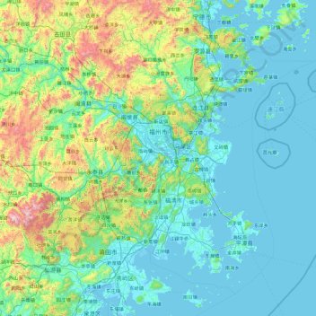
Name: 福州市 topographic map, elevation, terrain.
Location: 福州市, 福建省, 中国 (25.23631 118.37596 26.63844 120.19009)
Average elevation: 258 m
Minimum elevation: -4 m
Maximum elevation: 1,784 m
福州建城于公元前202年,迄今2200多年,是中国国家历史文化名城,在历史上长期作为福建的政治、经济、文化、交通中心,既是中国东南沿海重要的贸易港口和海上丝绸之路的起点城市之一,也是重要的文化中心,是中国东南沿海重要都市、中国人民解放军东部战区陆军机关驻地、二线城市。地理上,福州地貌属典型的河口盆地,盆地四周被群山峻岭所环抱,其海拔多在600-1000米之间。
Other topographic maps
Click on a map to view its topography, its elevation and its terrain.
武夷山国家级风景名胜区
武夷山国家级风景名胜区, 武夷街道, 武夷山市, 南平市, 福建省, 354300, 中国
Average elevation: 302 m