
岚谷乡 topographic map
Interactive map
Click on the map to display elevation.
About this map
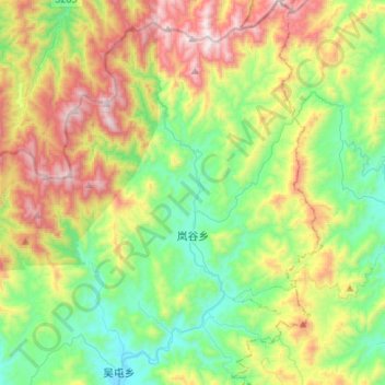
Name: 岚谷乡 topographic map, elevation, terrain.
Location: 岚谷乡, 武夷山市, 南平市, 福建省, 中国 (27.83966 118.08683 28.07904 118.26929)
Average elevation: 711 m
Minimum elevation: 269 m
Maximum elevation: 1,524 m
Other topographic maps
Click on a map to view its topography, its elevation and its terrain.
武夷山国家级风景名胜区
武夷山国家级风景名胜区, 武夷街道, 武夷山市, 南平市, 福建省, 354300, 中国
Average elevation: 302 m