
保定市 topographic map
Interactive map
Click on the map to display elevation.
About this map
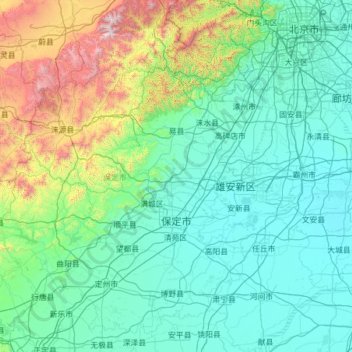
Name: 保定市 topographic map, elevation, terrain.
Location: 保定市, 河北省, 中国 (38.23222 113.75991 39.95121 116.24213)
Average elevation: 338 m
Minimum elevation: 2 m
Maximum elevation: 2,805 m
境内地形分为山区(含中山区、地山区和丘陵地区)、平原与洼淀区。山区约占总面积的49.68%,最高山为阜平县歪头山,海拔2286米,此为驼梁山,海拔2281米。平原约占总面积的47%,洼淀区约占3.23%。
Other topographic maps
Click on a map to view its topography, its elevation and its terrain.