
叉子沟 topographic map
Interactive map
Click on the map to display elevation.
About this map
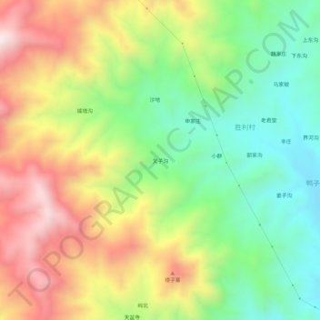
Name: 叉子沟 topographic map, elevation, terrain.
Location: 叉子沟, 易县, 保定市, 河北省, 中国 (39.35518 115.10462 39.39518 115.14462)
Average elevation: 604 m
Minimum elevation: 291 m
Maximum elevation: 1,010 m
Other topographic maps
Click on a map to view its topography, its elevation and its terrain.