
松江河镇 topographic map
Interactive map
Click on the map to display elevation.
About this map
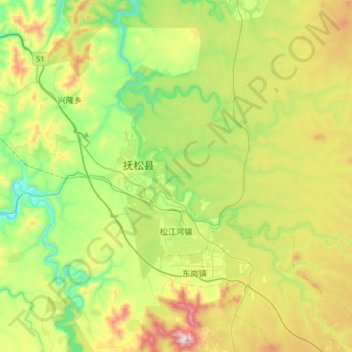
Name: 松江河镇 topographic map, elevation, terrain.
Location: 松江河镇, 抚松县, 白山市, 吉林省, 中国 (42.14645 127.38749 42.27340 127.71201)
Average elevation: 764 m
Minimum elevation: 515 m
Maximum elevation: 1,206 m
Other topographic maps
Click on a map to view its topography, its elevation and its terrain.