
Thank you for supporting this site ❤️
Make a donation
Make a donation
Gavião topographic map
Click on the map to display elevation.
Thank you for supporting this site ❤️
Make a donation
Make a donation
About this map
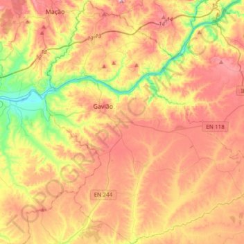
Name: Gavião topographic map, elevation, terrain.
Location: Gavião, Portalegre, Portugal (39.33406 -8.00888 39.56509 -7.74545)
Average elevation: 209 m
Minimum elevation: 26 m
Maximum elevation: 389 m
Thank you for supporting this site ❤️
Make a donation
Make a donation
Other topographic maps
Click on a map to view its topography, its elevation and its terrain.
Thank you for supporting this site ❤️
Make a donation
Make a donation
Barragens dos Estramontas
Portugal > Portalegre > Ponte de Sor > Foros do Arrão
Average elevation: 151 m
Thank you for supporting this site ❤️
Make a donation
Make a donation
Marvão
Portugal > Portalegre > Santa Maria de Marvão
Marvão é uma vila raiana portuguesa localizada no distrito de Portalegre, região Alentejo e sub-região do Alto Alentejo, com 398 habitantes, situada no topo da Serra do Sapoio, a uma altitude de 860 metros.
Average elevation: 557 m
Thank you for supporting this site ❤️
Make a donation
Make a donation
Thank you for supporting this site ❤️
Make a donation
Make a donation
Thank you for supporting this site ❤️
Make a donation
Make a donation
São Vicente e Ventosa
Portugal > Portalegre > São Vicente e Ventosa > São Vicente e Ventosa
Average elevation: 350 m
Thank you for supporting this site ❤️
Make a donation
Make a donation