
Thank you for supporting this site ❤️
Make a donation
Make a donation
Vargens topographic map
Click on the map to display elevation.
Thank you for supporting this site ❤️
Make a donation
Make a donation
About this map
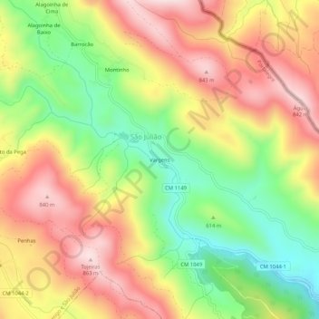
Name: Vargens topographic map, elevation, terrain.
Location: Vargens, Reguengo e São Julião, Portalegre, 7300-459, Portugal (39.28735 -7.31795 39.32735 -7.27795)
Average elevation: 639 m
Minimum elevation: 421 m
Maximum elevation: 847 m
Thank you for supporting this site ❤️
Make a donation
Make a donation
Other topographic maps
Click on a map to view its topography, its elevation and its terrain.