
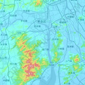
新会区 topographic map
Interactive map
Click on the map to display elevation.
About this map
Name: 新会区 topographic map, elevation, terrain.
Location: 新会区, 江门市, 广东省, 529100, 中国 (22.09783 112.79041 22.58042 113.25747)
Average elevation: 56 m
Minimum elevation: -6 m
Maximum elevation: 947 m
新會地勢西北高東南低,平原佔總面積的45.49%,有海湾冲积平原、三角洲冲积平原及山谷冲积平原。山地約佔總面積的35.53%,有圭峰山脈、古兜山脉和牛牯岭山脈,其中古兜山主峰獅子頭為新會最高点,海拔高度為982米。
Other topographic maps
Click on a map to view its topography, its elevation and its terrain.