
Wales topographic map
Interactive map
Click on the map to display elevation.
About this map
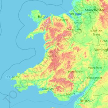
Name: Wales topographic map, elevation, terrain.
Location: Wales, United Kingdom (51.22903 -5.80773 53.63500 -2.64986)
Average elevation: 99 m
Minimum elevation: 0 m
Maximum elevation: 1,001 m
Much of Wales's diverse landscape is mountainous, particularly in the north and central regions. The mountains were shaped during the last ice age, the Devensian glaciation. The highest mountains in Wales are in Snowdonia (Eryri), of which five are over 1,000 m (3,300 ft). The highest of these is Snowdon (Yr Wyddfa), at 1,085 m (3,560 ft). The 14 Welsh mountains, or 15 if including Carnedd Gwenllian – often discounted because of its low topographic prominence – over 3,000 feet (910 metres) high are known collectively as the Welsh 3000s and are located in a small area in the north-west. The highest outside the 3000s is Aran Fawddwy, at 905 metres (2,969 feet), in the south of Snowdonia. The Brecon Beacons (Bannau Brycheiniog) are in the south (highest point Pen y Fan, at 886 metres (2,907 feet)), and are joined by the Cambrian Mountains in Mid Wales (highest point Pumlumon, at 752 metres (2,467 feet)).
Other topographic maps
Click on a map to view its topography, its elevation and its terrain.
West Bretton
United Kingdom > England > Wakefield
West Bretton, Wakefield, West Yorkshire, England, United Kingdom
Average elevation: 109 m
Crawford
United Kingdom > Scotland > South Lanarkshire
Crawford, South Lanarkshire, Scotland, ML12 6TP, United Kingdom
Average elevation: 314 m
Penarth
United Kingdom > Wales > Vale of Glamorgan
Penarth, Vale of Glamorgan, Wales, United Kingdom
Average elevation: 17 m
Cotswold District
United Kingdom > England > Gloucestershire
Cotswold District, Gloucestershire, England, United Kingdom
Average elevation: 118 m
Sheffield
Sheffield, South Yorkshire, England, United Kingdom
Average elevation: 168 m
Weston
United Kingdom > England > Cheshire East
Weston, Cheshire East, England, CW2 5GL, United Kingdom
Average elevation: 64 m
Sidcup
Sidcup, Greater London, England, DA14 6DH, United Kingdom
Average elevation: 56 m
Glastonbury
United Kingdom > England > Somerset
Glastonbury, Somerset, England, United Kingdom
Average elevation: 15 m
Kirkwall
United Kingdom > Scotland > Orkney Islands
Kirkwall, Orkney Islands, Scotland, KW15 1DH, United Kingdom
Average elevation: 27 m
Winsford
United Kingdom > England > Cheshire West and Chester
Winsford, Cheshire West and Chester, England, United Kingdom
Average elevation: 45 m
Tenby
United Kingdom > Wales > Pembrokeshire
Tenby, Pembrokeshire, Wales, United Kingdom
Average elevation: 15 m
Weymouth
United Kingdom > England > Dorset
Weymouth, Dorset, England, United Kingdom
Average elevation: 36 m
Bradford-on-Avon
United Kingdom > England > Wiltshire
Bradford-on-Avon, Wiltshire, England, United Kingdom
Average elevation: 71 m
Marlborough
United Kingdom > England > Wiltshire
Marlborough, Wiltshire, England, United Kingdom
Average elevation: 163 m
Malvern
United Kingdom > England > Worcestershire > Malvern Hills
Malvern, Malvern Hills, Worcestershire, England, WR14 2HX, United Kingdom
Average elevation: 95 m
New Forest National Park
United Kingdom > England > Hampshire
New Forest National Park, Hampshire, England, United Kingdom
Average elevation: 34 m
Weston-super-Mare
United Kingdom > England > North Somerset
Weston-super-Mare, North Somerset, England, United Kingdom
Average elevation: 9 m
Devizes
United Kingdom > England > Wiltshire
Devizes, Wiltshire, England, United Kingdom
Average elevation: 118 m
Dovedale
United Kingdom > England > Staffordshire > Staffordshire Moorlands
Dovedale, Ilam, Staffordshire Moorlands, Staffordshire, England, DE6 2AY, United Kingdom
Average elevation: 271 m
Port William
United Kingdom > Scotland > Dumfries and Galloway
Port William, Dumfries and Galloway, Scotland, DG8 9SJ, United Kingdom
Average elevation: 17 m
Tamworth
United Kingdom > England > Staffordshire
Tamworth, Staffordshire, England, United Kingdom
Average elevation: 76 m
Kintore
United Kingdom > Scotland > Aberdeenshire
Kintore, Aberdeenshire, Scotland, AB51 0US, United Kingdom
Average elevation: 88 m
Gordon Lake
United Kingdom > England > Kent > Gravesham > Gravesend
Gordon Lake, Milton, Gravesend, Gravesham, Kent, England, United Kingdom
Average elevation: 11 m
West Amesbury
United Kingdom > England > Wiltshire
West Amesbury, Wiltshire, England, SP4 7BH, United Kingdom
Average elevation: 90 m
Felton
United Kingdom > England > Herefordshire
Felton, Herefordshire, England, United Kingdom
Average elevation: 82 m
Hastings
United Kingdom > England > East Sussex
Hastings, East Sussex, England, United Kingdom
Average elevation: 36 m
Banbury
United Kingdom > England > Oxfordshire > Cherwell District
Banbury, Cherwell District, Oxfordshire, England, United Kingdom
Average elevation: 116 m
Holme-on-Spalding-Moor
United Kingdom > England > East Riding of Yorkshire
Holme-on-Spalding-Moor, East Riding of Yorkshire, England, YO43 4FL, United Kingdom
Average elevation: 8 m
Braintree
United Kingdom > England > Essex
Braintree, Essex, England, United Kingdom
Average elevation: 66 m
Amesbury
United Kingdom > England > Wiltshire > Amesbury
Amesbury, Wiltshire, England, United Kingdom
Average elevation: 103 m
Glenrothes
United Kingdom > Scotland > Fife
Glenrothes, Fife, Scotland, KY7 5NN, United Kingdom
Average elevation: 106 m
Newtownabbey
United Kingdom > Northern Ireland > County Antrim
Newtownabbey, County Antrim, Ulster, Northern Ireland, BT36 6UN, United Kingdom
Average elevation: 100 m
Greenock
United Kingdom > Scotland > Inverclyde
Greenock, Inverclyde, Scotland, PA15 1LT, United Kingdom
Average elevation: 80 m
Kilmeston
United Kingdom > England > Hampshire > Winchester
Kilmeston, Kilmiston, Winchester, Hampshire, England, SO24 0NP, United Kingdom
Average elevation: 113 m
Corwen
United Kingdom > Wales > Denbighshire
Corwen, Denbighshire, Wales, LL21 0DL, United Kingdom
Average elevation: 274 m
Highbury
United Kingdom > England > Gloucestershire > Forest of Dean > Lydney > Allaston
Highbury, Lydney, Allaston, Forest of Dean, Gloucestershire, England, GL15 5JQ, United Kingdom
Average elevation: 68 m
High Wycombe
United Kingdom > England > Buckinghamshire
High Wycombe, Buckinghamshire, England, United Kingdom
Average elevation: 124 m
Blakesley
United Kingdom > England > West Northamptonshire
Blakesley, West Northamptonshire, England, United Kingdom
Average elevation: 141 m
Maltby
Maltby, Rotherham, South Yorkshire Mayoral Combined Authority, England, United Kingdom
Average elevation: 91 m
Filton
United Kingdom > England > Filton
Filton, South Gloucestershire, South West England, England, BS34, United Kingdom
Average elevation: 68 m
Guildford
United Kingdom > England > Guildford
Guildford, Surrey, South East, England, United Kingdom
Average elevation: 74 m
London
London, Greater London, England, United Kingdom
Average elevation: 66 m
Shropshire (Ceremonial)
Shropshire (Ceremonial), England, United Kingdom
Average elevation: 143 m
Kirkcaldy
United Kingdom > Scotland > Fife
Kirkcaldy, Fife, Scotland, KY1 1JA, United Kingdom
Average elevation: 50 m
Yate
United Kingdom > England > South Gloucestershire
Yate, South Gloucestershire, West of England, England, United Kingdom
Average elevation: 83 m