Geolocate

Devizes topographic map

Interactive map

Click on the map to display elevation.

About this map

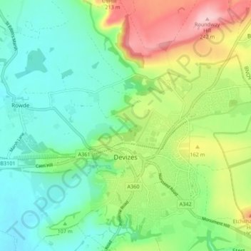
Name: Devizes topographic map, elevation, terrain.

Location: Devizes, Wiltshire, England, United Kingdom (51.33304 -2.02588 51.38514 -1.96327)

Average elevation: 118 m

Minimum elevation: 58 m

Maximum elevation: 241 m

Other topographic maps

Click on a map to view its topography, its elevation and its terrain.

Bradford-on-Avon

United Kingdom > England > Wiltshire

Bradford-on-Avon, Wiltshire, England, United Kingdom

Average elevation: 71 m

Marlborough

United Kingdom > England > Wiltshire

Marlborough, Wiltshire, England, United Kingdom

Average elevation: 163 m

West Amesbury

United Kingdom > England > Wiltshire

West Amesbury, Wiltshire, England, SP4 7BH, United Kingdom

Average elevation: 90 m

Amesbury

United Kingdom > England > Wiltshire > Amesbury

Amesbury, Wiltshire, England, United Kingdom

Average elevation: 103 m

Downton

United Kingdom > England > Wiltshire > Downton

Downton, Wiltshire, South West England, England, United Kingdom

Average elevation: 74 m