
New Forest National Park topographic map
Interactive map
Click on the map to display elevation.
About this map
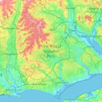
Name: New Forest National Park topographic map, elevation, terrain.
Location: New Forest National Park, Hampshire, England, United Kingdom (50.70574 -1.80348 51.00550 -1.30127)
Average elevation: 34 m
Minimum elevation: -4 m
Maximum elevation: 138 m
Other topographic maps
Click on a map to view its topography, its elevation and its terrain.