Geolocate

Herefordshire topographic map

Interactive map

Click on the map to display elevation.

About this map

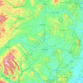
Name: Herefordshire topographic map, elevation, terrain.

Location: Herefordshire, England, United Kingdom (51.82594 -3.14192 52.39549 -2.33797)

Average elevation: 159 m

Minimum elevation: 5 m

Maximum elevation: 806 m

Other topographic maps

Click on a map to view its topography, its elevation and its terrain.

Devon

United Kingdom > England

Average elevation: 92 m

Matfield

United Kingdom > England > Kent > Tunbridge Wells

Average elevation: 82 m

Hyde Park

United Kingdom > England > London

"It consists of a screen of handsome fluted Ionic columns, with three carriage entrance archways, two-foot entrances, a lodge, etc. The extent of the whole frontage is about 107 ft (33 m). The central entrance has a bold projection: the entablature is supported by four columns; and the volutes of the capitals…

Average elevation: 25 m

Doncaster

United Kingdom > England

Average elevation: 31 m

West Bretton

United Kingdom > England > Wakefield

Average elevation: 109 m

Southampton

United Kingdom > England

Average elevation: 22 m

Sheffield

United Kingdom > England

Average elevation: 168 m

Weston

United Kingdom > England > Cheshire East

Average elevation: 64 m

Sidcup

United Kingdom > England

Average elevation: 56 m

Glastonbury

United Kingdom > England > Somerset

Average elevation: 15 m

Devizes

United Kingdom > England > Wiltshire

Average elevation: 118 m

Weymouth

United Kingdom > England > Dorset

Average elevation: 36 m

Bradford-on-Avon

United Kingdom > England > Wiltshire

Average elevation: 71 m

Marlborough

United Kingdom > England > Wiltshire

Marlborough has an oceanic climate somewhat influenced by its inland position and at 407 feet (124 m) elevation is more prone to frost than southern coastal areas. For example, in 1909 the town reported the equal lowest temperature in the UK at a station below 1,600 feet (500 m) for that year, with a…

Average elevation: 163 m

Malvern

United Kingdom > England > Worcestershire > Malvern Hills

Malvern lies in the Lower Severn/Avon plain affording it a degree of shelter caused by virtue of its nestling in between the Cotswold hills to the east, the Welsh Hills and Mountains to the west, and Birmingham plateau to the north. Although as with all the British Isles it has a maritime climate, the local…

Average elevation: 95 m

Tamworth

United Kingdom > England > Staffordshire

Average elevation: 76 m

Gordon Lake

United Kingdom > England > Kent > Gravesham > Gravesend

Average elevation: 11 m

West Amesbury

United Kingdom > England > Wiltshire

Average elevation: 90 m

Hastings

United Kingdom > England > East Sussex

Average elevation: 36 m

Felton

United Kingdom > England > Herefordshire

Average elevation: 82 m

Braintree

United Kingdom > England > Essex

Average elevation: 66 m

Amesbury

United Kingdom > England > Wiltshire > Amesbury

Average elevation: 103 m

Kilmeston

United Kingdom > England > Hampshire > Winchester

Average elevation: 113 m

High Wycombe

United Kingdom > England > Buckinghamshire

Average elevation: 124 m

Maltby

United Kingdom > England

Average elevation: 91 m

Filton

United Kingdom > England > Filton

Average elevation: 68 m

Shropshire (Ceremonial)

United Kingdom > England

The climate of Shropshire is moderate. Rainfall averages 760 to 1,000 mm (30 to 40 in), influenced by being in the rainshadow of the Cambrian Mountains from warm, moist frontal systems of the Atlantic Ocean which bring generally light precipitation in Autumn and Spring. The hilly areas in the south and west…

Average elevation: 143 m

Staffordshire

United Kingdom > England

Average elevation: 130 m

Guildford

United Kingdom > England > Guildford

Average elevation: 74 m

Warwickshire

United Kingdom > England

Average elevation: 111 m

London

United Kingdom > England

Average elevation: 66 m

Yate

United Kingdom > England > South Gloucestershire

Average elevation: 83 m

Central Bedfordshire

United Kingdom > England

Average elevation: 89 m

Bath

United Kingdom > England > Bath and North East Somerset

The floodplain of the Avon has an altitude of about 59 ft (18 m) above sea level, although the city centre is at an elevation of around 25 metres (82 ft) above sea level. The river, once an unnavigable series of braided streams broken up by swamps and ponds, has been managed by weirs into a single channel.…

Average elevation: 100 m

Downton

United Kingdom > England > Wiltshire > Downton

Average elevation: 74 m

Whitby

United Kingdom > England > North Yorkshire > Scarborough

Average elevation: 40 m