
泾阳县 topographic map
Interactive map
Click on the map to display elevation.
About this map
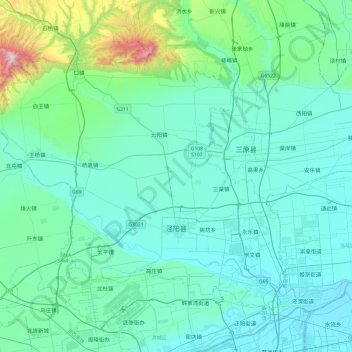
Name: 泾阳县 topographic map, elevation, terrain.
Location: 泾阳县, 咸阳市, 陕西省, 中国 (34.44019 108.49492 34.73823 108.97708)
Average elevation: 507 m
Minimum elevation: 356 m
Maximum elevation: 1,546 m
Other topographic maps
Click on a map to view its topography, its elevation and its terrain.