
旬邑县 topographic map
Interactive map
Click on the map to display elevation.
About this map
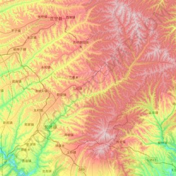
Name: 旬邑县 topographic map, elevation, terrain.
Location: 旬邑县, 咸阳市, 陕西省, 中国 (34.94647 108.11800 35.54454 108.87586)
Average elevation: 1,314 m
Minimum elevation: 792 m
Maximum elevation: 1,823 m
旬邑县位于陕西省中部偏西,咸阳市辖区的北端;东界黄陵、铜川、耀县,西邻彬县,南连淳化,北接甘肃正宁。处在关中平原的北界,黄土高原的南限;地势东北高西南低,平均海拔960-1350米;属暖温带大陆性气候,冬暖夏凉,日照时数长,昼夜温差大。
Other topographic maps
Click on a map to view its topography, its elevation and its terrain.