
Dagestan topographic map
Interactive map
Click on the map to display elevation.
About this map
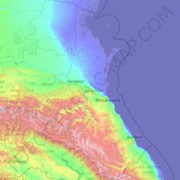
Name: Dagestan topographic map, elevation, terrain.
Location: Dagestan, North Caucasian Federal District, Russia (41.18510 45.10342 44.99172 48.80904)
Average elevation: 501 m
Minimum elevation: -31 m
Maximum elevation: 4,590 m
Other topographic maps
Click on a map to view its topography, its elevation and its terrain.
Барило-Крепинское сельское поселение
Russia > Rostov Oblast > Rodionovo-Nesvetaysky District
Average elevation: 135 m
Moscow
Moscow is situated on the banks of the Moskva River, which flows for just over 500 km (311 mi) through the East European Plain in central Russia, not far from the natural border of the forest and forest-steppe zone. 49 bridges span the river and its canals within the city's limits. The elevation of Moscow at…
Average elevation: 168 m
Omsk
Omsk is in the south of the West Siberian Plain, along the banks of the north-flowing Irtysh, at its confluence with the Om River. The city has an elevation of 87 meters (285 ft) above mean sea level at its highest point.
Average elevation: 107 m
Chelyabinsk Oblast
The West Siberian Plain is bounded on the west horizontal (elevation 190 m above sea level), which passes through the village of Bagaryak, Kunashak and continues through Chelyabinsk to the south. The lowlands are located in the northeast, and the elevation drops to 130 m in the eastern border region.
Average elevation: 301 m
Sverdlovsk-45
Russia > Sverdlovsk Oblast > городской округ Лесной > Sverdlovsk-45
Average elevation: 207 m
Заводопетровское
Russia > Tyumen Oblast > Yalutorovsky District > Заводопетровское
Average elevation: 75 m