
Tatarstan topographic map
Interactive map
Click on the map to display elevation.
About this map
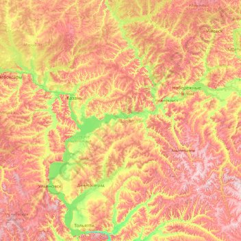
Name: Tatarstan topographic map, elevation, terrain.
Location: Tatarstan, Volga Federal District, Russia (53.97424 47.23702 56.67817 54.26570)
Average elevation: 147 m
Minimum elevation: 25 m
Maximum elevation: 381 m
Other topographic maps
Click on a map to view its topography, its elevation and its terrain.
Водолазово
Russia > Tyumen Oblast > Тушнолобовское сельское поселение > Водолазово
Average elevation: 74 m
Максимова
Russia > Tyumen Oblast > Тушнолобовское сельское поселение > Максимова
Average elevation: 75 m