
Thank you for supporting this site ❤️
Make a donation
Make a donation
Krasnodar Krai topographic map
Click on the map to display elevation.
Thank you for supporting this site ❤️
Make a donation
Make a donation
About this map
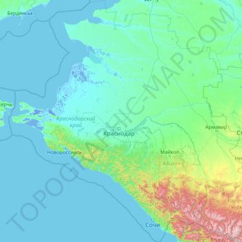
Name: Krasnodar Krai topographic map, elevation, terrain.
Location: Krasnodar Krai, Southern Federal District, Russia (43.22443 36.53049 47.00302 41.74398)
Average elevation: 202 m
Minimum elevation: -5 m
Maximum elevation: 3,767 m
Thank you for supporting this site ❤️
Make a donation
Make a donation
Other topographic maps
Click on a map to view its topography, its elevation and its terrain.
Thank you for supporting this site ❤️
Make a donation
Make a donation
Thank you for supporting this site ❤️
Make a donation
Make a donation
Thank you for supporting this site ❤️
Make a donation
Make a donation
Thank you for supporting this site ❤️
Make a donation
Make a donation
Заозерье
Russia > Moscow Oblast > городской округ Павловский Посад > Заозерье
Average elevation: 138 m
Thank you for supporting this site ❤️
Make a donation
Make a donation
Thank you for supporting this site ❤️
Make a donation
Make a donation
Заводопетровское
Russia > Tyumen Oblast > Yalutorovsky District > Заводопетровское
Average elevation: 75 m
Thank you for supporting this site ❤️
Make a donation
Make a donation
Thank you for supporting this site ❤️
Make a donation
Make a donation