
Chelyabinsk Oblast topographic map
Interactive map
Click on the map to display elevation.
Chelyabinsk Oblast
The West Siberian Plain is bounded on the west horizontal (elevation 190 m above sea level), which passes through the village of Bagaryak, Kunashak and continues through Chelyabinsk to the south. The lowlands are located in the northeast, and the elevation drops to 130 m in the eastern border region.
About this map
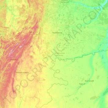
Name: Chelyabinsk Oblast topographic map, elevation, terrain.
Location: Chelyabinsk Oblast, Ural Federal District, Russia (51.99088 57.13129 56.36572 63.35201)
Average elevation: 301 m
Minimum elevation: 63 m
Maximum elevation: 1,525 m
Other topographic maps
Click on a map to view its topography, its elevation and its terrain.
Водолазово
Russia > Tyumen Oblast > Тушнолобовское сельское поселение > Водолазово
Average elevation: 74 m
Максимова
Russia > Tyumen Oblast > Тушнолобовское сельское поселение > Максимова
Average elevation: 75 m
Primorsky Krai
Highlands dominate the territory of the krai. Most of the territory is mountainous, and almost 80% of it is forested. The average elevation is about 500 meters (1,600 ft). Sikhote-Alin is a mountainous formation, extending for the most part of the Krai. It consists of a number of parallel ranges: the…
Average elevation: 255 m