
徐州市 topographic map
Interactive map
Click on the map to display elevation.
About this map
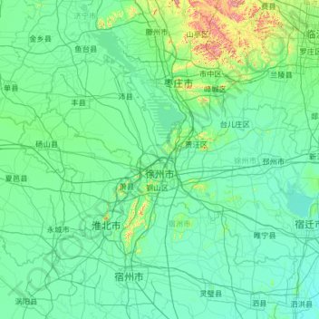
Name: 徐州市 topographic map, elevation, terrain.
Location: 徐州市, 江苏省, 221000, 中国 (33.71239 116.35520 34.97567 118.66874)
Average elevation: 50 m
Minimum elevation: 12 m
Maximum elevation: 614 m
徐州地处黄淮平原中部,属北方与南方的过渡地带,四周环山,平原、丘陵相间,属江苏省内平均海拔较高的市。徐州有大洞山、泉山、皇姑山、拉犁山、云龙山、小泰山、卧牛山等山峰,其中主城区有72座山头。位于贾汪区北部的大洞山为全市海拔最高点。徐州市全境森林覆盖率达30%以上,市区(主要建成区)绿化覆盖率达40%以上,均居江苏省各城市首位。
Other topographic maps
Click on a map to view its topography, its elevation and its terrain.