
梅江区 topographic map
Interactive map
Click on the map to display elevation.
About this map
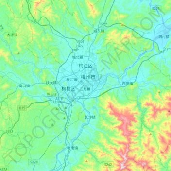
Name: 梅江区 topographic map, elevation, terrain.
Location: 梅江区, 梅州市, 广东省, 中国 (24.11287 115.98984 24.43570 116.33769)
Average elevation: 242 m
Minimum elevation: 59 m
Maximum elevation: 994 m
梅江区地理位置靠近北回归线,东近太平洋,气候温和,阳光充足,属亚热带季风气候区,受山区地形之影响,具有夏长冬短、雨量充沛且集中等低纬气候特点。有冷热悬殊,气流闭塞,易变旱涝灾害地形小气候突出等山区气候特点。四季宜耕宜牧,偶有奇热和严寒。主要灾害天气有:春季低温阴雨、倒春寒,5~6月间的台风雨,秋季寒露风和冬季霜冻等。水资源充足,有大小型水库30多座,库容2187.5万立方米。
Other topographic maps
Click on a map to view its topography, its elevation and its terrain.