
阴那山 topographic map
Interactive map
Click on the map to display elevation.
About this map
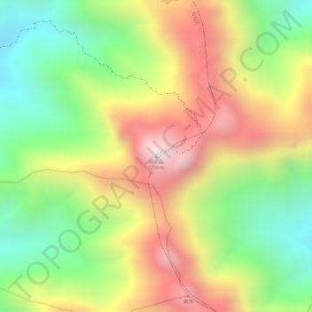
Name: 阴那山 topographic map, elevation, terrain.
Location: 阴那山, 梅州市, 广东省, 中国 (24.39415 116.41389 24.39425 116.41399)
Average elevation: 866 m
Minimum elevation: 484 m
Maximum elevation: 1,264 m
阴那山位于广东省梅州市梅县区和大埔县交界,为莲花山脉的主要高峰之一,主峰玉皇顶海拔1,298米,和罗浮山、南华山并称为粤东三胜。天气晴朗时在山顶可以望到潮州、汀州和梅州,因此有“白云深处望三州”的咏叹。
Other topographic maps
Click on a map to view its topography, its elevation and its terrain.