
濠江区 topographic map
Interactive map
Click on the map to display elevation.
About this map
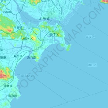
Name: 濠江区 topographic map, elevation, terrain.
Location: 濠江区, 汕头市, 广东省, 中国 (23.05037 116.61059 23.34816 117.12439)
Average elevation: 10 m
Minimum elevation: -5 m
Maximum elevation: 550 m
区内最高峰为掠鸟尾山,海拔278米。次高为香炉山,海拔212米,其次为汕头气象台所在的大瞭望山,海拔181米。其他主要的丘陵有东湖岭、小望山、皇帝帽石山、三界岭、象山、升旗山、笔架山、广澳大山、河渡山、虎仔山、叠石山等。
Other topographic maps
Click on a map to view its topography, its elevation and its terrain.