
澄海区 topographic map
Interactive map
Click on the map to display elevation.
About this map
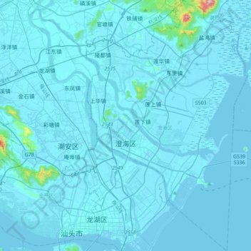
Name: 澄海区 topographic map, elevation, terrain.
Location: 澄海区, 汕头市, 广东省, 中国 (23.33313 116.69757 23.64845 116.91894)
Average elevation: 13 m
Minimum elevation: -2 m
Maximum elevation: 549 m
山丘主要有莲花山、南峙山、虎丘山、西陵山等,其中莲花山主峰海拔562米,为全区最高峰,也是汕头市大陆上的最高峰。澄海区为韩江主要入海口,韩江三条支流东里河、莲阳河、外砂河自北往南呈扇形流经全区,注入南海。海岸线长达66.9公里,浅海滩涂总面积为121.33平方公里。
Other topographic maps
Click on a map to view its topography, its elevation and its terrain.