
Make a donation
Cebu topographic map
Click on the map to display elevation.
Make a donation
Cebu
Coal was first discovered in Cebu about 1837. There were 15 localities over the whole island, on both coasts; some desultory mining had been carried out Naga near Mount Uling, but most serious operations were at Licos and Camansi west of Compostela and Danao. Active work ceased about 1895 with insurrections, and no production worked for more than ten years. A topographic and geologic survey of Compostela, Danao, and Carmen took place in 1906. The Compostela-Danao coalfield contained about six million workable tons. The tramroads, one from Danao to Camansi, one from Compostela to Mount Licos, were undertaken in 1895, together with a wagon road built in 1877, from Cotcot to Dapdap.
Make a donation
About this map
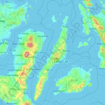
Name: Cebu topographic map, elevation, terrain.
Location: Cebu, Central Visayas, Philippines (9.32234 123.23527 11.62387 124.66718)
Average elevation: 91 m
Minimum elevation: -2 m
Maximum elevation: 2,362 m
Make a donation
Other topographic maps
Click on a map to view its topography, its elevation and its terrain.
Quezon City
Founded as a pueblo by Saint Pedro Bautista in 1590, San Francisco del Monte may be considered Quezon City's oldest district. The original land area of the old town of San Francisco del Monte was approximately2.5 square kilometres (1.0 sq mi) and covered parts of what is currently known as Project 7 and 8 and…
Average elevation: 57 m
Baguio
In 1903, Filipinos, Japanese and Chinese workers were hired to build Kennon Road, the first road directly connecting Baguio with the lowlands of La Union and Pangasinan. Before this, the only road to Benguet was Naguilian Road, and it was largely a horse trail at higher elevations. Camp John Hay was…
Average elevation: 881 m
Make a donation
Mandaue
It is one of the two (the other one being the municipality of Consolacion) local government units located within the mainland Metro Cebu where the elevation of land is less than 100 m (330 ft).
Average elevation: 109 m
Make a donation
Valencia
Philippines > Negros Oriental > Valencia
Valencia occupies an area of 14,749 hectares (36,450 acres), 35% of which are classified as plains. The town is 65% mountainous, with elevation averaging from 200 to 500 metres (660 to 1,640 ft) above sea level, with the top of Mount Talinis at an elevation of 1,903 metres (6,243 ft) along the municipal…
Average elevation: 250 m
Legazpi
Legazpi's topography is generally plain on the northeastern areas, with slopes ranging from five to fifteen degrees. The southern areas have mostly rolling to hilly terrain. In the city's coastal areas, the terrain varies from plain (north) to hilly (south). Legazpi is criss-crossed by several rivers including…
Average elevation: 150 m
Make a donation
Make a donation
Make a donation
Valenzuela
The highest elevation point is 38 meters (125 ft) above sea level. Having a surface gradient of 0.55% and a gentle slope, hilly landscape is located in the industrial section of the city in Canumay. The average elevation point is 2 meters (6.6 ft) above sea level.
Average elevation: 24 m
Make a donation
Make a donation
Make a donation
Make a donation
Make a donation
Make a donation
Make a donation
Make a donation
Make a donation
Make a donation
Make a donation
Make a donation
Make a donation
Make a donation
Make a donation
Make a donation
Make a donation
Tuba
Tuba's topography is generally characterized by irregular rugged terrain and steep slopes with several mountain peaks rising from the table land itself. Mount Santo Tomas, the highest peak in the municipality soars to 2,252 metres (7,388 ft) above sea level.
Average elevation: 1,242 m
Make a donation
San Juan
"San Juan" is a contraction of the city's traditional name of "San Juan del Monte" (lit. 'Saint John of the Mountain'). As with numerous other places in the Philippines, the name combines a patron saint and a toponym; in this case Saint John the Baptist with the locale's hilly terrain and relatively higher…
Average elevation: 35 m
Bacolod
Bacólod (English: Bacolod), is derived from bakólod (Old Spelling: bacólod), the Old Hiligaynon (Old Ilonggo) (Old Spelling: Ylongo and Ilongo) word for a "hill, turtle, mound, rise, hillock, down, any small eminence or elevation", since the resettlement was founded on a stony, hilly area, now the barangay…
Average elevation: 49 m
Make a donation
Antipolo
Its higher elevation than that of Metro Manila affords it a scenic view of the metropolis, especially at night. Its locally grown mangoes and cashews are popular among tourists, as well as suman – a local delicacy made out of glutinous rice. The Hinulugang Taktak National Park, which was once a popular…
Average elevation: 125 m
Mandaluyong
Another claims that the Spaniards named the place based on the report of a navigator named Acapulco, who saw the rolling hills frequently being lashed at by daluyong (“big waves from the sea”). This seems to confirm traditional pre-Hispanic stories that giant waves from the sea would meet the adjoining…
Average elevation: 33 m
Make a donation