Lake Sebu topographic map
Interactive map
Click on the map to display elevation.
About this map
![Lake Sebu topographic map, elevation, terrain](/pub/maps/node/s7b3/b9l8sk57/thumbnail.jpg)
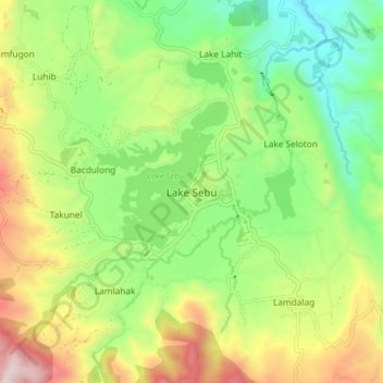
Name: Lake Sebu topographic map, elevation, terrain.
Location: Lake Sebu, South Cotabato, Soccsksargen, 9514, Philippines (6.18600 124.67157 6.26600 124.75157)
Average elevation: 750 m
Minimum elevation: 344 m
Maximum elevation: 1,389 m
The placid lake of Lake Sebu can be found in Allah Valley near the municipality of Surallah, South Cotabato. Surrounded by rolling hills and mountains covered with thick rain forest, the lake has an area of 354 hectares (870 acres), with an elevation of approximately 1,000 metres (3,300 ft).
Other topographic maps
Click on a map to view its topography, its elevation and its terrain.
![General Santos topographic map, elevation, terrain](/pub/maps/node/d814/j2h7cmnx/icon.jpg)
General Santos
Philippines > South Cotabato > General Santos
General Santos, South Cotabato, Soccsksargen, 9500, Philippines
Average elevation: 149 m
![Glamang topographic map, elevation, terrain](/pub/maps/node/3nh/9gzdcrmt/icon.jpg)
Glamang
Philippines > South Cotabato > Polomolok
Glamang, Polomolok, South Cotabato, Soccsksargen, 9504, Philippines
Average elevation: 223 m
![Lake Holon topographic map, elevation, terrain](/pub/maps/way/96z4/hk44btp/icon.jpg)
Lake Holon
Philippines > South Cotabato > T'Boli
Lake Holon, T'Boli, South Cotabato, Philippines
Average elevation: 1,452 m
![South Cotabato topographic map, elevation, terrain](/pub/maps/relation/mqtp/d7fk3l/icon.jpg)
South Cotabato
South Cotabato, Soccsksargen, Philippines
Average elevation: 352 m
![Tinagacan topographic map, elevation, terrain](/pub/maps/node/k1tf/9tbdgp3l/icon.jpg)
Tinagacan
Philippines > South Cotabato > General Santos > Tinagacan
Tinagacan, General Santos, South Cotabato, Soccsksargen, Philippines
Average elevation: 58 m
![Batomelong topographic map, elevation, terrain](/pub/maps/node/htrr/fwj34czs/icon.jpg)
Batomelong
Philippines > South Cotabato > General Santos > Batomelong
Batomelong, General Santos, South Cotabato, Soccsksargen, Philippines
Average elevation: 86 m