Geolocate

环山村 topographic map

Interactive map

Click on the map to display elevation.

About this map

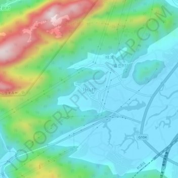
Name: 环山村 topographic map, elevation, terrain.

Location: 环山村, 温州市, 浙江省, 中国 (28.32146 121.08577 28.36146 121.12577)

Average elevation: 148 m

Minimum elevation: 2 m

Maximum elevation: 591 m

Other topographic maps

Click on a map to view its topography, its elevation and its terrain.

智仁乡

中国 > 浙江省 > 温州市

智仁乡, 温州市, 浙江省, 中国

Average elevation: 183 m

樟岙村

中国 > 浙江省 > 温州市

樟岙村, 温州市, 浙江省, 中国

Average elevation: 238 m

岙里村

中国 > 浙江省 > 温州市

岙里村, 温州市, 浙江省, 中国

Average elevation: 32 m

龙西乡

中国 > 浙江省 > 温州市

龙西乡, 温州市, 浙江省, 325616, 中国

Average elevation: 315 m

马鞍

中国 > 浙江省 > 温州市

马鞍, 温州市, 浙江省, 中国

Average elevation: 313 m

溪下乡

中国 > 浙江省 > 温州市

溪下乡, 温州市, 浙江省, 中国

Average elevation: 715 m

双峰乡

中国 > 浙江省 > 温州市

双峰乡, 温州市, 浙江省, 中国

Average elevation: 103 m

福建省星仔列岛省级海洋特别保护区

中国 > 浙江省 > 温州市

福建省星仔列岛省级海洋特别保护区, 温州市, 浙江省, 中国

Average elevation: 0 m

甲鼎山

中国 > 浙江省 > 温州市

甲鼎山, 温州市, 浙江省, 中国

Average elevation: 587 m

白马尖

中国 > 浙江省 > 温州市

白马尖, 温州市, 浙江省, 中国

Average elevation: 736 m

太石山

中国 > 浙江省 > 温州市

太石山, 温州市, 浙江省, 中国

Average elevation: 370 m

灵昆岛

中国 > 浙江省 > 温州市

灵昆岛, 温州市区, 洞头区, 温州市, 浙江省, 中国

Average elevation: 71 m