
金厂镇 topographic map
Interactive map
Click on the map to display elevation.
About this map
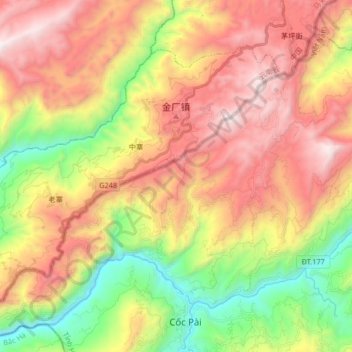
Name: 金厂镇 topographic map, elevation, terrain.
Location: 金厂镇, 马关县, 文山壮族苗族自治州, 云南省, 中国 (22.68822 104.34191 22.80216 104.50792)
Average elevation: 1,110 m
Minimum elevation: 241 m
Maximum elevation: 1,994 m
Other topographic maps
Click on a map to view its topography, its elevation and its terrain.