
高州市 topographic map
Interactive map
Click on the map to display elevation.
About this map
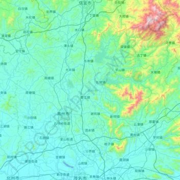
Name: 高州市 topographic map, elevation, terrain.
Location: 高州市, 茂名市, 广东省, 525200, 中国 (21.71010 110.61293 22.31324 111.37887)
Average elevation: 187 m
Minimum elevation: -10 m
Maximum elevation: 1,676 m
高州市地形复杂,地势大体是东北高,西南低。境内东北部是连绵的山地,中央腹地是起伏的丘陵,西部、南部的台地、小平原、山地及河谷小盆地相互交错。山地面积占 51.5%,丘陵面积占 31.9%,平原面积占 16.6%。一般山岭土层较厚,山地多粘质土,平坦的坡地则多沙土。地势最高点是东北部的棉被顶,海拔1627.3米,最低点是西南部祥山鉴江河床,海拔11.5米。
Other topographic maps
Click on a map to view its topography, its elevation and its terrain.