
Make a donation
Uttarakhand topographic map
Click on the map to display elevation.
Make a donation
Uttarakhand
Uttarakhand lies on the southern slope of the Himalaya range, and the climate and vegetation vary greatly with elevation, from glaciers at the highest elevations to subtropical forests at the lower elevations. The highest elevations are covered by ice and bare rock. Below them, between 3,000 and 5,000 metres (9,800 and 16,400 ft) are the western Himalayan alpine shrub and meadows. The temperate western Himalayan subalpine conifer forests grow just below the tree line. At 3,000 to 2,600 metres (9,800 to 8,500 ft) elevation they transition to the temperate western Himalayan broadleaf forests, which lie in a belt from 2,600 to 1,500 metres (8,500 to 4,900 ft) elevation. Below 1,500 metres (4,900 ft) elevation lie the Himalayan subtropical pine forests. The Upper Gangetic Plains moist deciduous forests and the drier Terai-Duar savanna and grasslands cover the lowlands along the Uttar Pradesh border in a belt locally known as Bhabar. These lowland forests have mostly been cleared for agriculture, but a few pockets remain.
Make a donation
About this map
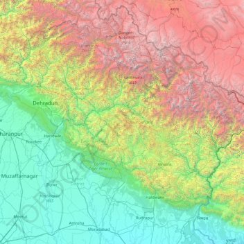
Name: Uttarakhand topographic map, elevation, terrain.
Location: Uttarakhand, India (28.72432 77.57133 31.45902 80.87903)
Average elevation: 2,107 m
Minimum elevation: 170 m
Maximum elevation: 7,657 m
Make a donation
Other topographic maps
Click on a map to view its topography, its elevation and its terrain.
Chandoli National Park
India > Maharashtra > Shirala
The park spreads along the crest of the Sahyadri Range of the northern Western Ghats. It forms and protects many perennial water channels, water holes and the Vasant Sagar Reservoir. Elevation of the park ranges from 589–1,044 m (1,932–3,425 ft). The park receives its water supply from the Warna river and…
Average elevation: 749 m
Make a donation
Chittoor
India > Andhra Pradesh > Chittoor
It is located between the northern latitudes of 37" and 14°8" and between the eastern longitudes 78°33" and 79°55". It is bounded on the east by Tirupati district of Andhra Pradesh, on the south by Krishnagiri District , Vellore, Tiruvallur,Thirupattur districts of Tamil Nadu, on the west by Kolar district…
Average elevation: 350 m
Make a donation
Make a donation
Varanasi
India > Uttar Pradesh > Sadar
Varanasi is located at an elevation of 80.71 metres (264.8 ft) in the centre of the Ganges valley of North India, in the Eastern part of the state of Uttar Pradesh, along the left crescent-shaped bank of the Ganges, averaging between 15 metres (50 ft) and 21 metres (70 ft) above the river. The city is the…
Average elevation: 77 m
Bagalkote
India > Karnataka > Bagalakote taluk
Bagalakote, is a city in the state of Karnataka, India, which is also the headquarters of Bagalakote district. It is situated on branch of River Ghataprabha about 481 km (299 mi) northwest of state capital Bengaluru, 410 km (255 mi) southwest of Hyderabad, and about 570 km (354 mi) southeast of Mumbai. The…
Average elevation: 556 m
Auroville
India > Tamil Nadu > Vanur
It is included in the sub-humid tropics (wet-and-dry tropical climate) situated on a plateau region with its maximum elevation of 32 m (105 ft) above sea level located in the Matrimandir area. The annual rainfall average is 1,200 mm (47 in) mainly from the SW monsoon (June to Sept.) and NE monsoon (Nov to Dec)…
Average elevation: 36 m
Make a donation
Sliding Rock
India > Andhra Pradesh > Kurabalakota > Mandemvaripalli > Sriramavaripalli
Average elevation: 740 m
Palanpur
India > Gujarat > Palanpur Taluka
Palanpur is located at 24°06′N 72°15′E / 24.10°N 72.25°E / 24.10; 72.25. It has an average elevation of 209 metres (685 ft).
Average elevation: 218 m
Make a donation
Bengaluru
India > Karnataka > Bangalore North > Bengaluru
Bangalore (/bæŋɡəˈlɔːr/), officially known as Bengaluru (Kannada pronunciation: (listen)), is the capital and the largest city of the Indian state of Karnataka. It has a population of more than 8 million and a metropolitan population of around 11 million, making it the third most populous city and fifth…
Average elevation: 879 m
Badami
India > Karnataka > Badami taluku
Badami is located at 15°55′N 75°41′E / 15.92°N 75.68°E / 15.92; 75.68. It has an average elevation of 586 metres (1922 ft). It is located at the mouth of a ravine between two rocky hills and surrounds Agastya tirtha water reservoir on the three other sides. The total area of the town is 10.3…
Average elevation: 587 m
Make a donation
Make a donation