
管城回族区 topographic map
Interactive map
Click on the map to display elevation.
About this map
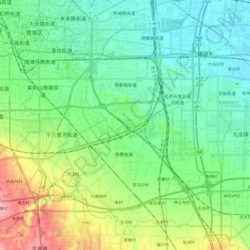
Name: 管城回族区 topographic map, elevation, terrain.
Location: 管城回族区, 郑州市, 河南省, 中国 (34.61237 113.65358 34.76702 113.86483)
Average elevation: 112 m
Minimum elevation: 81 m
Maximum elevation: 192 m
管城回族区位于郑州市东南部,东临中牟县,南连新郑市,北与金水区相接,西接二七区。地势由西南向东北倾斜,最高点为十八里河街道柴郭村与青天卢村相连的岗顶,海拔为200米,最低处为圃田乡的石王村。境内有熊儿河、十八里河、七里河、潮河四条河流,均属淮河水系。
Other topographic maps
Click on a map to view its topography, its elevation and its terrain.