
Lazio topographic map
Interactive map
Click on the map to display elevation.
About this map
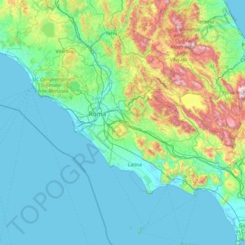
Name: Lazio topographic map, elevation, terrain.
Location: Lazio, Italy (40.78493 11.44917 42.83873 14.02764)
Average elevation: 335 m
Minimum elevation: -3 m
Maximum elevation: 2,720 m
Other topographic maps
Click on a map to view its topography, its elevation and its terrain.
Bondone
Italy > Trentino-Alto Adige/Südtirol > Provincia di Trento
The territory of the commune rises from an elevation of 368 metres (1,207 ft) at the lakeside to a maximum of 1,946 metres (6,385 ft). The Castello di San Giovanni, offers panoramic views of the lake, and of the valley of the Chiese, with the Dolomites of Brenta visible in the distance. Bondone is a member of…
Average elevation: 843 m
Lombardy
Lombardy has a wide array of climates due to variance in elevation, proximity to inland water basins, and large metropolitan areas. The climate is mainly humid subtropical (Köppen Cfa), especially in the plains, though with significant variations to the Köppen model, especially in the normally long, damp,…
Average elevation: 797 m
Campania
The climate is typically Mediterranean along the coast with warm, sunny and sultry summers and mild, rainy winters, whereas in the inner zones it is more continental, with lower temperatures in winter and warm summers. Snow is possible at higher elevations but rare at sea level. 51% of the total area is hilly,…
Average elevation: 323 m
Sardinia
The climate of the island is variable from area to area, due to several factors including the extension in latitude and the elevation. It can be classified in two different macrobioclimates (Mediterranean pluviseasonal oceanic and Temperate oceanic), one macrobioclimatic variant (Submediterranean), and four…
Average elevation: 109 m
Piedmont
Piedmont has a typically temperate climate, which on the Alps becomes progressively temperate-cold and colder as it climbs to altitude. In areas located at low altitudes, winters are relatively cold but not very rainy and often sunny, with the possibility of snowfall, sometimes abundant. Snowfall, on the other…
Average elevation: 1,082 m
Großhorn - Corno Grande
Italy > Trentino-Alto Adige/Südtirol > Graun - Curon Venosta
Average elevation: 2,295 m
Brindisi
Brindisi enjoys a Mediterranean climate (Köppen: Csa). Summers are hot and sometimes humid with abundant sunshine. Summer heat indexes can be regularly over 30 °C (86 °F) and occasionally as high as 37 °C during July and August. Winters are mild with frequent rain. Brindisi and the mostly topographically…
Average elevation: 80 m
Macerata
Typically hilly, the climate is both Mediterranean and continental. The Adriatic Sea, which is approximately 30 kilometres (19 mi) away, and particularly the Apennine Mountains influence the weather. The elevation of Macerata is approximately 315 metres (1,033 ft) above sea level, so winter is particularly…
Average elevation: 562 m
Catania
Around 263 BC, the city was variously known as Catĭna (Latin: ) and Catăna (Latin: ; Ancient Greek: Κατάνη ). The former has been primarily used for its supposed assonance with catina, the Latin feminization of the name catinus. Catinus has two meanings: "a gulf, a basin or a bay" and "a bowl, a vessel…
Average elevation: 50 m