
Macerata topographic map
Interactive map
Click on the map to display elevation.
Macerata
Typically hilly, the climate is both Mediterranean and continental. The Adriatic Sea, which is approximately 30 kilometres (19 mi) away, and particularly the Apennine Mountains influence the weather. The elevation of Macerata is approximately 315 metres (1,033 ft) above sea level, so winter is particularly rainy and the snow is not so frequent and plentiful. Balkanic and northwestern perturbations may cause snow. Middle seasons are variable, and late snowfall and frost may occur during April. October is neither warm nor very cold. Summer is rather sunny, and sometimes the thermometer reaches 40 °C (104 °F). Garbino is the cause, a hot wind from the hinterland. Summer thunderstorms are frequent in August during the evening, when the weather becomes quite unstable.
About this map
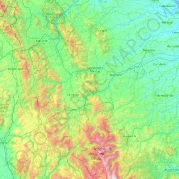
Name: Macerata topographic map, elevation, terrain.
Location: Macerata, Marche, Italy (42.83185 12.82965 43.47421 13.74328)
Average elevation: 562 m
Minimum elevation: 4 m
Maximum elevation: 2,436 m