
Make a donation
Lombardy topographic map
Click on the map to display elevation.
Make a donation
Lombardy
Lombardy has a wide array of climates due to variance in elevation, proximity to inland water basins, and large metropolitan areas. The climate is mainly humid subtropical (Köppen Cfa), especially in the plains, though with significant variations to the Köppen model, especially in the normally long, damp, and cold winters. There is high seasonal temperature variation; in Milan, average temperature is 2.5 °C (36.5 °F) in January and 24 °C (75 °F) in July. The plains are often subject to fog during the coldest months.
Make a donation
About this map
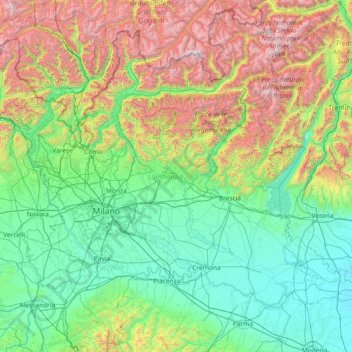
Name: Lombardy topographic map, elevation, terrain.
Location: Lombardy, Italy (44.67991 8.49785 46.63535 11.42765)
Average elevation: 797 m
Minimum elevation: 8 m
Maximum elevation: 3,853 m
Make a donation
Other topographic maps
Click on a map to view its topography, its elevation and its terrain.
Make a donation
Großhorn - Corno Grande
Italy > Trentino-Alto Adige/Südtirol > Graun - Curon Venosta
Average elevation: 2,295 m
Make a donation