
Make a donation
Campania topographic map
Click on the map to display elevation.
Make a donation
Campania
The climate is typically Mediterranean along the coast with warm, sunny and sultry summers and mild, rainy winters, whereas in the inner zones it is more continental, with lower temperatures in winter and warm summers. Snow is possible at higher elevations but rare at sea level. 51% of the total area is hilly, 34% mountainous and the remaining 15% is made up of plains. There is a high seismic risk across the region.
Make a donation
About this map
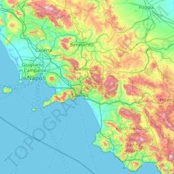
Name: Campania topographic map, elevation, terrain.
Location: Campania, Italy (39.99052 13.76238 41.50808 15.80645)
Average elevation: 323 m
Minimum elevation: -3 m
Maximum elevation: 2,015 m
Make a donation
Other topographic maps
Click on a map to view its topography, its elevation and its terrain.
Make a donation
Großhorn - Corno Grande
Italy > Trentino-Alto Adige/Südtirol > Graun - Curon Venosta
Average elevation: 2,295 m
Make a donation