
Thank you for supporting this site ❤️
Make a donation
Make a donation
Bondone topographic map
Click on the map to display elevation.
Thank you for supporting this site ❤️
Make a donation
Make a donation
Bondone
The territory of the commune rises from an elevation of 368 metres (1,207 ft) at the lakeside to a maximum of 1,946 metres (6,385 ft). The Castello di San Giovanni, offers panoramic views of the lake, and of the valley of the Chiese, with the Dolomites of Brenta visible in the distance. Bondone is a member of the I Borghi più belli d'Italia ("The most beautiful villages of Italy") association.
Thank you for supporting this site ❤️
Make a donation
Make a donation
About this map
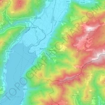
Name: Bondone topographic map, elevation, terrain.
Average elevation: 843 m
Minimum elevation: 353 m
Maximum elevation: 1,786 m
Thank you for supporting this site ❤️
Make a donation
Make a donation