
龙岗镇 topographic map
Interactive map
Click on the map to display elevation.
About this map
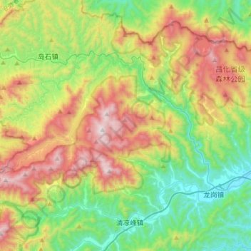
Name: 龙岗镇 topographic map, elevation, terrain.
Location: 龙岗镇, 临安区, 杭州市, 浙江省, 中国 (30.12003 118.88781 30.33341 119.16228)
Average elevation: 658 m
Minimum elevation: 122 m
Maximum elevation: 1,584 m
Other topographic maps
Click on a map to view its topography, its elevation and its terrain.