
Greece topographic map
Interactive map
Click on the map to display elevation.
Greece
Greece's topography is predominantly mountainous, with approximately 80% of its terrain consisting of mountains or hills, making it one of the most mountainous countries in Europe. The Pindus mountain range, often referred to as the "spine of Greece," runs through the center of the mainland from northwest to southeast, reaching elevations up to 2,637 meters at Mount Smolikas, the country's second-highest peak. This range extends into the Peloponnese and continues underwater, forming many of the Aegean Islands, including Crete. Mount Olympus, the highest peak in Greece at 2,918 meters, is located on the border between Thessaly and Macedonia and is renowned in mythology as the abode of the Greek gods. In addition to its rugged mountains, Greece features deep gorges, such as the Vikos Gorge in the Pindus range, and extensive coastlines with numerous islands, contributing to its diverse and dramatic terrain.
About this map
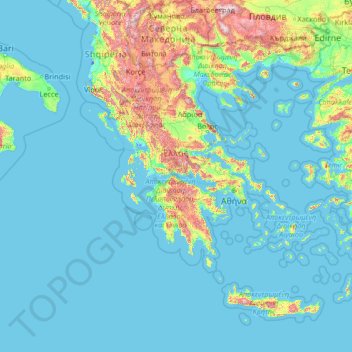
Name: Greece topographic map, elevation, terrain.
Location: Greece (34.71889 19.11275 41.74889 29.68381)
Average elevation: 170 m
Minimum elevation: -7 m
Maximum elevation: 2,734 m
Other topographic maps
Click on a map to view its topography, its elevation and its terrain.
Lichtenburg
South Africa > North West > Ngaka Modiri Molema District Municipality > Ditsobotla Local Municipality
Average elevation: 1,480 m
Loutropigi
Greece > Thessaly and Central Greece > Karditsa Regional Unit > Municipal Unit of Menelaida
Average elevation: 563 m
Amfissa
Greece > Thessaly and Central Greece > Regional Unit of Phocis > Municipal Unit of Amfissa
Average elevation: 506 m
Kakamas
South Africa > Northern Cape > ZF Mgcawu District Municipality > Kai !Garib Local Municipality
Average elevation: 667 m
Iztaccíhuatl
Mexico > Puebla > San Salvador el Verde
The name "Iztaccíhuatl" is Nahuatl for "White (like salt) woman", reflecting the four individual snow-capped peaks which depict the head, chest, knees and feet of a sleeping female when seen from east or west. Iztaccíhuatl is to the north of its twin Popocatépetl, to which it is connected by the high…
Average elevation: 4,732 m
Popocatépetl
Mexico > State of Mexico > Atlautla
According to paleomagnetic studies, the volcano is about 730,000 years old. It is cone shaped with a diameter of 25 km (16 mi) at its base, with a peak elevation of 5,450 m (17,880 ft). The crater is elliptical with an orientation northeast-southwest. The walls of the crater vary from 600 to 840 m (1,970 to…
Average elevation: 4,810 m
Šavnik
Montenegro > Šavnik Municipality
Šavnik (Cyrillic: Шавник, pronounced [ʃǎv̞niːk]) is a town in Montenegro in the northern region and administrative center of the Šavnik Municipality. It is located at the confluence of three rivers - Bukovica, Bijela and Šavnik, at an altitude of 840 meters. It is the lowest lying settlement in…
Average elevation: 1,021 m
Žabljak
Montenegro > Žabljak Municipality
Žabljak is the seat of Žabljak Municipality (2011 population: 3,569). The town is in the centre of the Durmitor mountain region and with an altitude of 1,456 metres, it is the highest situated Balkan town.
Average elevation: 1,461 m
Pljevlja
Montenegro > Pljevlja Municipality
The town lies at an altitude of 770 m (2,530 ft). In the Middle Ages, Pljevlja had been a crossroad of the important commercial roads and cultural streams, with important roads connecting the littoral with the Balkan interior. In 2023, the municipality of Pljevlja had a population of 24,542, while the city…
Average elevation: 845 m
The Matterhorn
United States > Connecticut > Northwest Hills Planning Region > Canaan
Average elevation: 462 m
Brava
Cape Verde > Brava > Furna
North of Brava are several uninhabited islets; the largest ones are Ilhéu de Cima and Ilhéu Grande. Monte Fontainhas is the highest point on the island, reaching 976 metres elevation.
Average elevation: 212 m
Gusinje
Montenegro > Gusinje Municipality
The town is located in the Plav-Gusinje area, part of the upper Lim valley in the Accursed Mountains range at an elevation of 1,014 m. Zla Kolata, the highest mountain in Montenegro about 10 km south of Gusinje in the Prokletije National Park.
Average elevation: 1,295 m
Kolašin
Montenegro > Kolašin Municipality > Kolašin
Kolašin is located on the foot of Bjelasica and Sinjajevina mountains, which offer great conditions for skiing. Because of Kolašin's altitude (954 m), the town is considered an air spa.
Average elevation: 1,133 m
Mojkovac
Montenegro > Mojkovac Municipality
The municipality of Mojkovac covers an area of 367 km2 (142 sq mi) and according to the number of inhabitants (10 015 / 2003g) belongs among the smaller municipalities in Montenegro. The city resort is located at an altitude of 853 m (2,799 ft). Its mathematical position is determined by geographical…
Average elevation: 898 m
Ribeira Grande de Santiago (Cidade Velha)
Cape Verde > Ribeira Grande de Santiago
Average elevation: 56 m
Kabgayi
Rwanda > Southern Province > Muhanga District > Nyamabuye
Kabgayi lies in the middle of Rwanda's central plateau at an elevation of about 6,000 feet (1,800 m) above sea level. Located in Kamazuru Village of Gahogo Cell in Nyamabuye Sector, it is a 5 minutes’ drive from Muhanga City. The community is just south of Gitarama, the second-largest city in Rwanda, and…
Average elevation: 1,835 m
Swansea
United Kingdom > Wales > Swansea
Much of Swansea is hilly, with the main area of upland being located in the council ward of Mawr. Areas up to 185 metres (607 ft) in elevation range across the central section: Kilvey Hill, Townhill and Llwynmawr separate the centre of Swansea from its northern suburbs. Cefn Bryn, a ridge of high land, is the…
Average elevation: 73 m
Siliguri
India > West Bengal > Siliguri Subdivsion
Siliguri is located at the foothills of the eastern Himalayas at a location of 26°43′N 88°26′E / 26.71°N 88.43°E / 26.71; 88.43. The city is spread over an area of 260 km2 (100 sq mi) within the Siliguri Corridor, and has earned a moniker the Chicken's neck. The city is surrounded by dense…
Average elevation: 121 m
Pezoula
Greece > Thessaly and Central Greece > Karditsa Regional Unit > Nevropoli Agrafon Municipal Unit
Average elevation: 1,032 m
Royton
Described in Samuel Lewis's A Topographical Dictionary of England (1848) as being in "aspect rather wild", Royton lies in a shallow valley amongst undulating land. The sources of the rivers Irk and Beal are to the northeast and east respectively. The Irk meanders southwesterly into Chadderton, and then onwards…
Average elevation: 181 m
Sal
The island is 29.7 km long and 11.8 km wide. Its area is 219.84 km2 (84.88 sq mi). It is one of the three sandy eastern islands (Sal, Boa Vista and Maio) of the archipelago, with white sandy beaches. The island is fairly flat; its highest point is Monte Grande, at 406 m elevation. The uninhabited islet Ilhéu…
Average elevation: 7 m
Grube - Fossa
Italy > Trentino – Alto Adige/Südtirol > South Tyrol > Oberradein - Redagno di Sopra
Average elevation: 1,477 m
Shoa Robit
Shewa Robit (Amharic: ሸዋ ሮቢት)also known as Robi, Shah Robit, Shoa Robit or Robit is a town in north-central Ethiopia. Located in the North Shewa Zone of the Amhara Region, this town has a longitude and latitude of 10°00′N 39°54′E / 10.000°N 39.900°E / 10.000; 39.900 with an elevation…
Average elevation: 1,360 m
São Vicente
The island is roughly rectangular in shape with an area of 226.7 square kilometres (87.5 square miles). From east to west it measures 24.3 kilometres (15.1 miles) and from north to south 16.3 kilometres (10.1 miles). The island, of volcanic origin, is fairly flat. The last volcanic activity is considered to…
Average elevation: 46 m
Kuala Lumpur
Located in the centre of Selangor state, Kuala Lumpur was a territory of Selangor State Government. In 1974, Kuala Lumpur was split off from Selangor to form the first Federal Territory governed directly by the Malaysian federal government. Its location in the most developed state on the west coast of…
Average elevation: 127 m
Macubeni Dam
South Africa > Eastern Cape > Chris Hani District Municipality > Emalahleni Local Municipality
Average elevation: 1,347 m
Ehden
Ehden is located in the central northern side of Mount Lebanon, with a 1500-metre (at Midan square) elevation from sea level. It is 120 kilometres (75 mi) from Beirut, 30 kilometres (19 mi) from Tripoli and 25 kilometres (16 mi) from Zgharta. Ehden used to be the sole residence for Zghartians prior to the…
Average elevation: 1,350 m
Laloki River
Papua New Guinea > National Capital District > National Capital District > Port Moresby
Average elevation: 38 m
Markersbach
Germany > Saxony > Erzgebirgskreis
In 1889, Markersbach was connected to the railway line from Schwarzenberg to Annaberg, which was closed to passenger transport on 27 September 1997. The station lay in Mittweida’s municipal area and the platform signs read Mittweida-Markersbach. To overcome the great elevation differential, the railway's…
Average elevation: 600 m
Gorak Shep
Nepal > Koshi Province > Solukhumbu
Gorak Shep, also spelled Gorakshep (Nepali: गोरकशेप, गोरक्षेप), is a settlement nestled on the periphery of a frozen lakebed blanketed with sand in Nepal, sharing its name with the locale. Situated at an elevation of 5,164 meters (16,942 feet) near Mount Everest, it remains…
Average elevation: 5,255 m