
Make a donation
Markersbach topographic map
Click on the map to display elevation.
Make a donation
Markersbach
In 1889, Markersbach was connected to the railway line from Schwarzenberg to Annaberg, which was closed to passenger transport on 27 September 1997. The station lay in Mittweida’s municipal area and the platform signs read Mittweida-Markersbach. To overcome the great elevation differential, the railway's alignment takes it along a broad bow through the community. Furthermore, three bridges are needed to cross narrow dales.
Make a donation
About this map
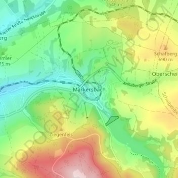
Name: Markersbach topographic map, elevation, terrain.
Average elevation: 600 m
Minimum elevation: 461 m
Maximum elevation: 827 m
Make a donation
Other topographic maps
Click on a map to view its topography, its elevation and its terrain.
Make a donation
Marienberg
Germany > Saxony > Erzgebirgskreis
The town is situated on a plateau north of the Ore Mountains ridge, at an elevation between 460 and 891 metres above sea level. It is approximately 31 kilometres south of Chemnitz, to which it is connected via the Flöha Valley Railway.
Average elevation: 657 m
Make a donation
Make a donation
Make a donation