
Vojvodina topographic map
Interactive map
Click on the map to display elevation.
About this map
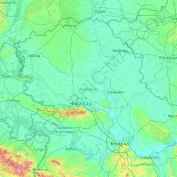
Name: Vojvodina topographic map, elevation, terrain.
Location: Vojvodina, Serbia (44.62973 18.81499 46.19028 21.56013)
Average elevation: 110 m
Minimum elevation: 66 m
Maximum elevation: 860 m
Today, the western part of Syrmia is in Croatia, the northern part of Bačka is in Hungary, the eastern part of Banat is in Romania (with a small piece in Hungary), while Baranja (which is between the Danube and the Drava) is in Hungary and Croatia. Vojvodina has a total surface area of 21,500 km2 (8,300 sq mi). Vojvodina is also part of the Danube-Kris-Mures-Tisa euroregion. The Gudurica peak (Gudurički vrh) on the Vršac Mountains, is the highest peak in Vojvodina, at an altitude of 641 m above sea level.
Other topographic maps
Click on a map to view its topography, its elevation and its terrain.
Stari Ledinci
Serbia > Vojvodina > South Backa Administrative District
Stari Ledinci, City of Novi Sad, South Backa Administrative District, Vojvodina, 21206, Serbia
Average elevation: 255 m
Despotovac
Serbia > Central Serbia > Pomoravlje Administrative District > Despotovac Municipality
Despotovac, Despotovac Municipality, Pomoravlje Administrative District, Central Serbia, 35213, Serbia
Average elevation: 259 m
Vlaska
Serbia > Central Serbia > City of Belgrade > Mladenovac Urban Municipality
Vlaska, Mladenovac Urban Municipality, City of Belgrade, Central Serbia, Serbia
Average elevation: 225 m
Rabrovac
Serbia > Central Serbia > City of Belgrade > Mladenovac Urban Municipality
Rabrovac, Mladenovac Urban Municipality, City of Belgrade, Central Serbia, Serbia
Average elevation: 160 m
Mladenovac Urban Municipality
Serbia > Central Serbia > City of Belgrade
Mladenovac Urban Municipality, City of Belgrade, Central Serbia, Serbia
Average elevation: 211 m
Boljevci
Serbia > Central Serbia > City of Belgrade > Surcin Urban Municipality
Boljevci, Surcin Urban Municipality, City of Belgrade, Central Serbia, 11275, Serbia
Average elevation: 76 m
Barajevo
Serbia > Central Serbia > City of Belgrade > Barajevo Urban Municipality
Barajevo, Barajevo Urban Municipality, City of Belgrade, Central Serbia, 11460, Serbia
Average elevation: 175 m
Koracica
Serbia > Central Serbia > City of Belgrade > Mladenovac Urban Municipality
Koracica, Mladenovac Urban Municipality, City of Belgrade, Central Serbia, Serbia
Average elevation: 251 m
Jagnjilo
Serbia > Central Serbia > City of Belgrade > Mladenovac Urban Municipality
Jagnjilo, Mladenovac Urban Municipality, City of Belgrade, Central Serbia, Serbia
Average elevation: 155 m
Novi Slankamen
Serbia > Vojvodina > Srem Administrative District > Indjija Municipality
Novi Slankamen, Indjija Municipality, Srem Administrative District, Vojvodina, 22323, Serbia
Average elevation: 130 m
Парк Луке Ћеловића
Serbia > Central Serbia > City of Belgrade > Belgrade
Парк Луке Ћеловића, Београд (Савски венац), Savski Venac Urban Municipality, Belgrade, City of Belgrade, Central Serbia, 11000, Serbia
Average elevation: 98 m
Brezovac
Serbia > Central Serbia > Sumadija Administrative District > Arandjelovac Municipality
Brezovac, Arandjelovac Municipality, Sumadija Administrative District, Central Serbia, Serbia
Average elevation: 380 m
Krepoljin
Serbia > Central Serbia > Branicevo Administrative District > Zagubica Municipality
Krepoljin, Zagubica Municipality, Branicevo Administrative District, Central Serbia, 12316, Serbia
Average elevation: 423 m
Kopljare
Serbia > Central Serbia > Sumadija Administrative District > Arandjelovac Municipality
Kopljare, Arandjelovac Municipality, Sumadija Administrative District, Central Serbia, 34312, Serbia
Average elevation: 213 m
Orasac
Serbia > Central Serbia > Sumadija Administrative District > Arandjelovac Municipality
Orasac, Arandjelovac Municipality, Sumadija Administrative District, Central Serbia, Serbia
Average elevation: 246 m
Orasac
Serbia > Central Serbia > Jablanica Administrative District
Orasac, City of Leskovac, Jablanica Administrative District, Central Serbia, Serbia
Average elevation: 389 m
Gornja Tresnjevica
Serbia > Central Serbia > Sumadija Administrative District > Arandjelovac Municipality
Gornja Tresnjevica, Arandjelovac Municipality, Sumadija Administrative District, Central Serbia, Serbia
Average elevation: 385 m
Begaljica
Serbia > Central Serbia > City of Belgrade > Grocka Urban Municipality
Begaljica, Grocka Urban Municipality, City of Belgrade, Central Serbia, 11306, Serbia
Average elevation: 182 m
Mirosaljci
Serbia > Central Serbia > Zlatibor Administrative District > Arilje Municipality
Mirosaljci, Arilje Municipality, Zlatibor Administrative District, Central Serbia, Serbia
Average elevation: 441 m
Krcevac
Serbia > Central Serbia > Sumadija Administrative District > Topola Municipality
Krcevac, Topola Municipality, Sumadija Administrative District, Central Serbia, Serbia
Average elevation: 179 m
Тришићи
Serbia > Central Serbia > Macva Administrative District > Mali Zvornik Municipality
Тришићи, Radalj, Mali Zvornik Municipality, Macva Administrative District, Central Serbia, 15321, Serbia
Average elevation: 280 m
Stojnik
Serbia > Central Serbia > City of Belgrade > Sopot Urban Municipality
Stojnik, Sopot Urban Municipality, City of Belgrade, Central Serbia, Serbia
Average elevation: 230 m
Ducina
Serbia > Central Serbia > City of Belgrade > Sopot Urban Municipality
Ducina, Sopot Urban Municipality, City of Belgrade, Central Serbia, Serbia
Average elevation: 221 m
Dragolj
Serbia > Central Serbia > Moravica Administrative District > Gornji Milanovac Municipality
Dragolj, Gornji Milanovac Municipality, Moravica Administrative District, Central Serbia, Serbia
Average elevation: 292 m
Dulene
Serbia > Central Serbia > Sumadija Administrative District
Dulene, City of Kragujevac, Sumadija Administrative District, Central Serbia, Serbia
Average elevation: 615 m
Mionica
Serbia > Central Serbia > Kolubara Administrative District > Mionica Municipality
Mionica, Mionica Municipality, Kolubara Administrative District, Central Serbia, 14242, Serbia
Average elevation: 212 m
Ljutice
Serbia > Central Serbia > Zlatibor Administrative District > Pozega Municipality
Ljutice, Pozega Municipality, Zlatibor Administrative District, Central Serbia, Serbia
Average elevation: 663 m
Mionica
Serbia > Central Serbia > Zlatibor Administrative District > Kosjeric Municipality
Mionica, Kosjeric Municipality, Zlatibor Administrative District, Central Serbia, Serbia
Average elevation: 570 m
Trsic
Serbia > Central Serbia > Macva Administrative District
Trsic, City of Loznica, Macva Administrative District, Central Serbia, 15303, Serbia
Average elevation: 246 m
Donji Taor
Serbia > Central Serbia > Kolubara Administrative District
Donji Taor, Taor, City of Valjevo, Kolubara Administrative District, Central Serbia, Serbia
Average elevation: 822 m
Kremna
Serbia > Central Serbia > Zlatibor Administrative District > Uzice
Kremna, Uzice, City of Užice, Zlatibor Administrative District, Central Serbia, Serbia
Average elevation: 880 m
Ravno Selo
Serbia > Vojvodina > South Backa Administrative District > Vrbas Municipality
Ravno Selo, Vrbas Municipality, South Backa Administrative District, Vojvodina, Serbia
Average elevation: 82 m
Ljig
Serbia > Central Serbia > Kolubara Administrative District > Ljig Municipality
Ljig, Ljig Municipality, Kolubara Administrative District, Central Serbia, 14240, Serbia
Average elevation: 222 m
Velika Ivanca
Serbia > Central Serbia > City of Belgrade > Mladenovac Urban Municipality
Velika Ivanca, Mladenovac Urban Municipality, City of Belgrade, Central Serbia, Serbia
Average elevation: 226 m
Šabac
Serbia > Central Serbia > Macva Administrative District
Šabac, City of Šabac, Macva Administrative District, Central Serbia, 15000, Serbia
Average elevation: 81 m
Popina
Serbia > Central Serbia > Rasina Administrative District > Trstenik Municipality
Popina, Trstenik Municipality, Rasina Administrative District, Central Serbia, 37240, Serbia
Average elevation: 317 m
Avala
Serbia > Central Serbia > City of Belgrade > Beli Potok
Avala, Beli Potok, City of Belgrade, Central Serbia, 11223, Serbia
Average elevation: 297 m
Baric
Serbia > Central Serbia > City of Belgrade > Obrenovac Urban Municipality
Baric, Obrenovac Urban Municipality, City of Belgrade, Central Serbia, 11506, Serbia
Average elevation: 109 m
Gradska opština Sevojno
Serbia > Central Serbia > Zlatibor Administrative District
Gradska opština Sevojno, City of Užice, Zlatibor Administrative District, Central Serbia, 31205, Serbia
Average elevation: 525 m
Busije
Serbia > Central Serbia > City of Belgrade > Zemun Urban Municipality
Busije, Угриновци, Zemun Urban Municipality, City of Belgrade, Central Serbia, 22330, Serbia
Average elevation: 77 m
Raspogance
Serbia > Central Serbia > Zlatibor Administrative District > Sjenica Municipality
Raspogance, Sjenica Municipality, Zlatibor Administrative District, Central Serbia, Serbia
Average elevation: 1,145 m
Petnica
Serbia > Central Serbia > Kolubara Administrative District
Petnica, Kolubara Administrative District, Central Serbia, 14000, Serbia
Average elevation: 237 m
Valjevo City
Serbia > Central Serbia > Kolubara Administrative District
Valjevo City, Kolubara Administrative District, Central Serbia, Serbia
Average elevation: 433 m
Belgrade
Serbia > Central Serbia > City of Belgrade
Belgrade, City of Belgrade, Central Serbia, Serbia
Average elevation: 108 m
Jagodina City
Serbia > Central Serbia > Pomoravlje Administrative District
Jagodina City, Pomoravlje Administrative District, Central Serbia, Serbia
Average elevation: 218 m
Srezovac
Serbia > Central Serbia > Nisava Administrative District > Aleksinac Municipality
Srezovac, Aleksinac Municipality, Nisava Administrative District, Central Serbia, 18224, Serbia
Average elevation: 185 m
Midžor
Serbia > Central Serbia > Pirot Administrative District > City of Pirot
Midžor, City of Pirot, Pirot Administrative District, Central Serbia, Serbia
Average elevation: 1,810 m
Rogaca
Serbia > Central Serbia > City of Belgrade > Sopot Urban Municipality
Rogaca, Sopot Urban Municipality, City of Belgrade, Central Serbia, Serbia
Average elevation: 241 m
Arandjelovac
Serbia > Central Serbia > Sumadija Administrative District > Arandjelovac Municipality
Arandjelovac, Arandjelovac Municipality, Sumadija Administrative District, Central Serbia, 34300, Serbia
Average elevation: 326 m
Misaca
Serbia > Central Serbia > Sumadija Administrative District > Arandjelovac Municipality
Misaca, Arandjelovac Municipality, Sumadija Administrative District, Central Serbia, Serbia
Average elevation: 264 m