
Make a donation
Dragolj topographic map
Click on the map to display elevation.
Make a donation
About this map
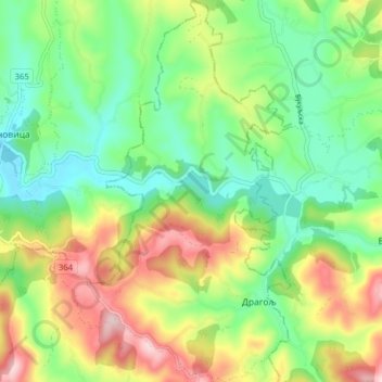
Name: Dragolj topographic map, elevation, terrain.
Average elevation: 292 m
Minimum elevation: 187 m
Maximum elevation: 466 m
Make a donation
Other topographic maps
Click on a map to view its topography, its elevation and its terrain.
Lozanj
Serbia > Central Serbia > Moravica Administrative District > Gornji Milanovac Municipality
Average elevation: 509 m
Gornji Milanovac
Serbia > Central Serbia > Moravica Administrative District > Gornji Milanovac Municipality
Gornji Milanovac and the villages of Varnice, Zagradje, Dragolj and Trudelj are dominated by the Ostrvica Massif. The elevation of Ostrvica is 758 metres (2,487 ft). Ostrvica is actually the remains of a destroyed volcanic cone. In May 2009, Ostrvica was declared a natural monument. In the middle of the last…
Average elevation: 412 m