
Arandjelovac topographic map
Interactive map
Click on the map to display elevation.
About this map
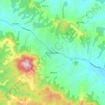
Name: Arandjelovac topographic map, elevation, terrain.
Average elevation: 326 m
Minimum elevation: 186 m
Maximum elevation: 688 m
Other topographic maps
Click on a map to view its topography, its elevation and its terrain.
Orasac
Serbia > Central Serbia > Sumadija Administrative District > Arandjelovac Municipality
Average elevation: 246 m
Brezovac
Serbia > Central Serbia > Sumadija Administrative District > Arandjelovac Municipality
Average elevation: 380 m
Gornja Tresnjevica
Serbia > Central Serbia > Sumadija Administrative District > Arandjelovac Municipality
Average elevation: 385 m
Misaca
Serbia > Central Serbia > Sumadija Administrative District > Arandjelovac Municipality
Average elevation: 264 m