
凤阳县 topographic map
Interactive map
Click on the map to display elevation.
About this map
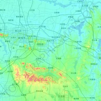
Name: 凤阳县 topographic map, elevation, terrain.
Location: 凤阳县, 滁州市, 安徽省, 中国 (32.61680 117.15433 33.05006 117.94418)
Average elevation: 44 m
Minimum elevation: 11 m
Maximum elevation: 332 m
凤阳县位于北纬32°37′-33°03′、东经117°19′-117°57′之间,地处淮河中游南岸。地形北低南高,北部是沿淮冲积平原,中部是倾降平缓的岗丘,南部是山区;平均海拔15-17米,最高山峰为狼窝山,海拔340.3米。境内石英岩和石灰岩资源丰富,特别是石英岩矿已初步探明储量约100亿吨,储量和品位均位居华东之首、全国前列。
Other topographic maps
Click on a map to view its topography, its elevation and its terrain.