Geolocate

滁州市 topographic map

Interactive map

Click on the map to display elevation.

About this map

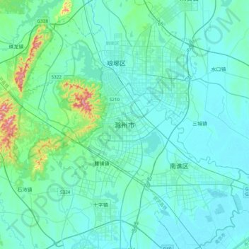
Name: 滁州市 topographic map, elevation, terrain.

Location: 滁州市, 琅琊区, 滁州市, 安徽省, 中国 (32.09459 118.16805 32.41459 118.48805)

Average elevation: 38 m

Minimum elevation: 4 m

Maximum elevation: 314 m

Other topographic maps

Click on a map to view its topography, its elevation and its terrain.

花园湖

中国 > 安徽省 > 滁州市

花园湖, 滁州市, 安徽省, 中国

Average elevation: 19 m

牛郢村

中国 > 安徽省 > 滁州市

牛郢村, 滁州市, 安徽省, 中国

Average elevation: 29 m

官沟社区

中国 > 安徽省 > 滁州市

官沟社区, 滁州市, 安徽省, 中国

Average elevation: 51 m

江山村

中国 > 安徽省 > 滁州市

江山村, 滁州市, 安徽省, 中国

Average elevation: 31 m

定远县

中国 > 安徽省 > 滁州市

定远县, 滁州市, 安徽省, 中国

Average elevation: 59 m

半塔镇

中国 > 安徽省 > 滁州市

半塔镇, 滁州市, 安徽省, 中国

Average elevation: 52 m

谕兴

中国 > 安徽省 > 滁州市

谕兴, 滁州市, 安徽省, 中国

Average elevation: 50 m

Langya Shan

中国 > 安徽省 > 滁州市

Langya Shan, 滁州市, 安徽省, 中国

Average elevation: 179 m

凤阳县

中国 > 安徽省 > 滁州市

凤阳县, 滁州市, 安徽省, 中国

Average elevation: 44 m