Geolocate

Lampung topographic map

Interactive map

Click on the map to display elevation.

Lampung

Between 1969 and 1970, the total area of forest land in Lampung that had been used was 249,200 hectares. In 2000, there were 48 permits issued; in 1980, the number reached 76 permits. The topography of the region in the western part is mostly hilly, while the eastern part is mostly a lowland area that is agricultural and swampy. In 1950, nine specimens per 100 square kilometres in Lampung were collected as part of botanical research.

Wikipedia (CC-BY-SA 3.0)

About this map

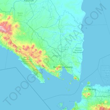
Name: Lampung topographic map, elevation, terrain.

Location: Lampung, Sumatra, Indonesia (-6.45503 103.50688 -3.72374 106.84665)

Average elevation: 111 m

Minimum elevation: -2 m

Maximum elevation: 2,686 m

Other topographic maps

Click on a map to view its topography, its elevation and its terrain.

Buayan

Indonesia > Central Java > Kebumen

Average elevation: 85 m

Babar Island

Indonesia > Maluku > Maluku Barat Daya

Average elevation: 177 m

Calaca

Indonesia > North Sulawesi > Manado

Average elevation: 11 m

Pariangan

Indonesia > West Sumatra > Tanah Datar

Average elevation: 1,040 m

Bukit Tinggi

Indonesia > Jambi > Bungo

Average elevation: 283 m

Genting

Indonesia > West Kalimantan > Kayong Utara

Average elevation: 29 m

Enrekang

Indonesia > South Sulawesi

Average elevation: 1,008 m

Purwodadi

Indonesia > East Java > Purwodadi

Average elevation: 80 m

Konawe

Indonesia > Southeast Sulawesi > Konawe

Average elevation: 30 m

Sembawang

Indonesia > West Kalimantan > Sembawang

Average elevation: 68 m

Wanua Tagulandang

Indonesia > North Sulawesi

Average elevation: 4 m

Biaro Island

Indonesia > North Sulawesi

Average elevation: 4 m

Pulau Derawan

Indonesia > East Kalimantan

Average elevation: 2 m

Pulau Sodang-besar

Indonesia > East Kalimantan

Average elevation: 53 m

Terempa Barat

Indonesia > Riau Islands > Terempa Barat

Average elevation: 250 m

West Sulawesi

Indonesia > West Sulawesi

Average elevation: 219 m

Sudimoro

Indonesia > Central Java > Sudimoro

Average elevation: 249 m

Pasir Raja

Indonesia > West Java > Rancakalong

Average elevation: 1,355 m

Dusun Lubuk Mayan

Indonesia > Jambi > Dusun Lubuk Mayan

Average elevation: 109 m

Tanggerang

Indonesia > West Kalimantan > Tanggerang

Average elevation: 51 m

Mendahara Ulu

Indonesia > Jambi > Mendahara Ulu

Average elevation: 18 m

Sitinjak

Indonesia > North Sumatra > South Tapanuli > Sitinjak

Average elevation: 208 m

Sepanjangjaya

Indonesia > West Java > Sepanjangjaya

Average elevation: 24 m