
Thank you for supporting this site ❤️
Make a donation
Make a donation
Cedar Knob topographic map
Click on the map to display elevation.
Thank you for supporting this site ❤️
Make a donation
Make a donation
About this map
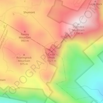
Name: Cedar Knob topographic map, elevation, terrain.
Average elevation: 845 m
Minimum elevation: 451 m
Maximum elevation: 1,140 m
Thank you for supporting this site ❤️
Make a donation
Make a donation
Other topographic maps
Click on a map to view its topography, its elevation and its terrain.
James F. Crowe Memorial Park
United States > North Carolina > Rutherford County > Forest City > River Hills
Average elevation: 274 m