
Thank you for supporting this site ❤️
Make a donation
Make a donation
Lake Lure topographic map
Click on the map to display elevation.
Thank you for supporting this site ❤️
Make a donation
Make a donation
About this map
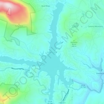
Name: Lake Lure topographic map, elevation, terrain.
Location: Lake Lure, Rutherford County, North Carolina, United States (35.41595 -82.23490 35.46091 -82.18222)
Average elevation: 375 m
Minimum elevation: 265 m
Maximum elevation: 873 m
Thank you for supporting this site ❤️
Make a donation
Make a donation
Other topographic maps
Click on a map to view its topography, its elevation and its terrain.
Deerfield
United States > North Carolina > Rutherford County > Lake Lure > Deerfield
Average elevation: 502 m