
Thank you for supporting this site ❤️
Make a donation
Make a donation
Spindale topographic map
Click on the map to display elevation.
Thank you for supporting this site ❤️
Make a donation
Make a donation
About this map
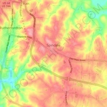
Name: Spindale topographic map, elevation, terrain.
Average elevation: 305 m
Minimum elevation: 241 m
Maximum elevation: 343 m
Thank you for supporting this site ❤️
Make a donation
Make a donation
Other topographic maps
Click on a map to view its topography, its elevation and its terrain.
Rutherfordton
United States > North Carolina > Rutherford County > Rutherfordton
Average elevation: 300 m
Chimney Rock
United States > North Carolina > Rutherford County > Chimney Rock
Average elevation: 550 m
Thank you for supporting this site ❤️
Make a donation
Make a donation
James F. Crowe Memorial Park
United States > North Carolina > Rutherford County > Forest City > River Hills
Average elevation: 274 m
Deerfield
United States > North Carolina > Rutherford County > Lake Lure > Deerfield
Average elevation: 502 m
Thank you for supporting this site ❤️
Make a donation
Make a donation
Thank you for supporting this site ❤️
Make a donation
Make a donation