
平原镇 topographic map
Interactive map
Click on the map to display elevation.
About this map
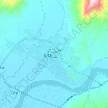
Name: 平原镇 topographic map, elevation, terrain.
Location: 平原镇, 盈江县, 德宏傣族景颇族自治州, 云南省, 665000, 中国 (24.66921 97.89638 24.74921 97.97638)
Average elevation: 863 m
Minimum elevation: 807 m
Maximum elevation: 1,456 m
1926年,盏达第十九任土司刀思必治之子思鸿升根据地形改名为“平原”。
Other topographic maps
Click on a map to view its topography, its elevation and its terrain.